1980s Maps of Nephi, Utah
Explore 2 historic maps of Nephi from the 1980s. These maps offer a rare glimpse into what life looked like during the 1980s — showing old roads, neighborhoods, homes, and landmarks that have changed or disappeared over time.
Whether you're researching your family's past, planning a metal detecting trip, or studying how Nephi's landscape evolved across the 1980s, these high-resolution maps are a powerful tool for exploring the history of this region.
- Focus on a specific era: All maps on this page are from the 1980s, giving you a focused view of this time period.
- See what’s changed: Compare century-old streets, trails, and buildings to today's modern landscape using overlays and satellite layers.
- Research with precision: Use these maps for genealogy, historical research, land use analysis, or educational projects.
- View, download, or print: Maps are fully viewable online in high resolution, and can be downloaded or printed for your own records.
Start exploring Nephi's history through authentic maps from the 1980s. This is your window into the past.
Nephi, UT maps
(2)- 1981 Map of Nephi
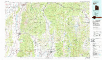 1981 Nephi1981 Print · USGSThe Juab and Sanpete valleys of central Utah are captured here in the early 1980s, during a period of established mountain settlement and rail-based commerce. Researchers can trace the routes of the Union Pacific and visit traditional communities like Nephi, Mount Pleasant, and Scofield.3 unique versions available
 - 1983 Map of Nephi
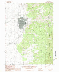 1983 Nephi1983 Print · USGSJuab Valley life in the early eighties is centered around the growing hub of Nephi and the mountain-flanked village of Levan. Genealogists and researchers can trace the local landscape through the Cem, resource sites like Quarries, and named springs including Old Pinery Springs.2 unique versions available
End of results
Showing maps 1-2 of 2
Top cities near Nephi
- Mona historical maps
- Fountain Green historical maps
- Rocky Ridge historical maps
- Levan historical maps
- Wales historical maps
Frequently asked questions
- What are the different types of historical maps available for Nephi?
- What is the oldest map of Nephi?
- Where can I purchase historical maps of Nephi for my home or office?
- Where can I download high-res historical maps of Nephi?
- Are there historical topographic maps available for Nephi?
- Is there historical aerial imagery available for Nephi?
- Where are historical maps of Nephi sourced from?