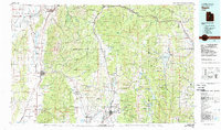
1981 Map of Nephi
USGS Topo · Published 1981About this map
Nephi serves as a central hub for the Juab Valley in this 1981 survey, positioned at the base of the Wasatch Range. The landscape is defined by its north-south valleys and the high plateaus that separate them, with the Sanpete Valley to the east containing a string of agricultural and mountain settlements like Mount Pleasant, Fountain Green, and Fairview. The transportation network is remarkably well-defined, showing the paths of the Union Pacific and Denver and Rio Grande Western railroads as they navigate the canyons and basins. Water management is a critical theme across the region, evidenced by the presence of the Mona Reservoir, Scofield Reservoir, and Chicken Creek Reservoir. These features, along with various state wildlife management areas like Big Hollow, illustrate the 1980s balance between irrigation, recreation, and the high-elevation terrain of the Uinta National Forest.
Find a feature on this map
62 named features on this map. Tap any name to fly to it.
Don’t see what you’re looking for? This feature index may not catch every label — zoom into the map to look around manually.
Map Details
Editions of this 1981 Nephi Map
3 editions found
Other maps of this area

1885 · Salt Lake
USGS Topo · 1:250,000

1885 · Manti
USGS Topo · 1:250,000

1885 · Sevier Desert
USGS Topo · 1:250,000

1885 · Uinta
USGS Topo · 1:250,000

1885 · Tooele Valley
USGS Topo · 1:250,000

1886 · Price River
USGS Topo · 1:250,000

1895 · Manti
USGS Topo · 1:250,000

1896 · Price River
USGS Topo · 1:250,000

1907 · Strawberry Valley
USGS Topo · 1:125,000

1909 · Strawberry Valley
USGS Topo · 1:125,000