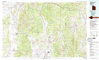
1981 Map of Nephi
USGS Topo · Published 1991About this map
Juab Valley and the Sanpete Valley anchor this 1980s landscape, where the high peaks of the Wasatch Range divide the Great Basin from the drainage of the San Pitch River. The map documents a period when regional transport relied heavily on the corridor shared by the Union Pacific RR and Denver & Rio Grande Western RR, which wind through steep terrain like Spanish Fork Canyon. At the base of Mount Nebo, the city of Nephi serves as a central hub, while smaller agricultural settlements like Fountain Green, Moroni, and Fairview dot the valleys. This survey also details extensive public lands within the Manti-La Sal National Forest and Uinta National Forest, including the recreational waters of Scofield Reservoir. The topography captures the transition from irrigated valley floors to the high, forested ridges of the Wasatch Plateau.
Find a feature on this map
64 named features on this map. Tap any name to fly to it.
Don’t see what you’re looking for? This feature index may not catch every label — zoom into the map to look around manually.
Map Details
Editions of this 1981 Nephi Map
3 editions found
Other maps of this area

1885 · Salt Lake
USGS Topo · 1:250,000

1885 · Manti
USGS Topo · 1:250,000

1885 · Sevier Desert
USGS Topo · 1:250,000

1885 · Uinta
USGS Topo · 1:250,000

1885 · Tooele Valley
USGS Topo · 1:250,000

1886 · Price River
USGS Topo · 1:250,000

1895 · Manti
USGS Topo · 1:250,000

1896 · Price River
USGS Topo · 1:250,000

1907 · Strawberry Valley
USGS Topo · 1:125,000

1909 · Strawberry Valley
USGS Topo · 1:125,000