1990s Maps of Milton, Utah
Explore 2 historic maps of Milton from the 1990s. These maps offer a rare glimpse into what life looked like during the 1990s — showing old roads, neighborhoods, homes, and landmarks that have changed or disappeared over time.
Whether you're researching your family's past, planning a metal detecting trip, or studying how Milton's landscape evolved across the 1990s, these high-resolution maps are a powerful tool for exploring the history of this region.
- Focus on a specific era: All maps on this page are from the 1990s, giving you a focused view of this time period.
- See what’s changed: Compare century-old streets, trails, and buildings to today's modern landscape using overlays and satellite layers.
- Research with precision: Use these maps for genealogy, historical research, land use analysis, or educational projects.
- View, download, or print: Maps are fully viewable online in high resolution, and can be downloaded or printed for your own records.
Start exploring Milton's history through authentic maps from the 1990s. This is your window into the past.
Milton, UT maps
(2)- 1991 Map of Morgan
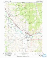 1991 Morgan1991 Print · USGSMorgan Valley's river-fed agriculture and mountain settlements are shown in detail during the early nineties. Researchers can trace irrigation works like the Gateway Canal and find local landmarks from Como Springs to the Milton Cem.
 - 1997 Map of Morgan, 2001 Print
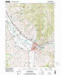 1997 Morgan2001 Print · USGSThe Morgan Valley at the close of the twentieth century shows a landscape shaped by the Weber River and the Union Pacific railroad. Researchers can locate the Milton Cem, trace the irrigation network from the Stoddard Diversion Dam, and find family landmarks like Roswells Spring Hollow.
End of results
Showing maps 1-2 of 2
Top cities near Milton
- Salt Lake City historical maps
- Ogden historical maps
- Layton historical maps
- Bountiful historical maps
- Kaysville historical maps
- Farmington historical maps
See more
Frequently asked questions
- What are the different types of historical maps available for Milton?
- What is the oldest map of Milton?
- Where can I purchase historical maps of Milton for my home or office?
- Where can I download high-res historical maps of Milton?
- Are there historical topographic maps available for Milton?
- Is there historical aerial imagery available for Milton?
- Where are historical maps of Milton sourced from?