1900s (20th Century) Maps of Bluff, Utah
Explore 9 historic maps of Bluff from the 1900s (20th Century). These maps offer a rare glimpse into what life looked like during the 1900s — showing old roads, neighborhoods, homes, and landmarks that have changed or disappeared over time.
Whether you're researching your family's past, planning a metal detecting trip, or studying how Bluff's landscape evolved across the 1900s, these high-resolution maps are a powerful tool for exploring the history of this region.
- Focus on a specific era: All maps on this page are from the 1900s, giving you a focused view of this time period.
- See what’s changed: Compare century-old streets, trails, and buildings to today's modern landscape using overlays and satellite layers.
- Research with precision: Use these maps for genealogy, historical research, land use analysis, or educational projects.
- View, download, or print: Maps are fully viewable online in high resolution, and can be downloaded or printed for your own records.
Start exploring Bluff's history through authentic maps from the 1900s. This is your window into the past.
Bluff, UT maps
(9)- 1956 Map of Cortez, 1972 Print
 1956 Cortez1972 Print · USGSThe Four Corners region comes alive in this mid-century study of the high plateaus and deep canyons surrounding Cortez. Trace the development of desert outposts like Towaoc or follow the historic Laramie Trail across a landscape dotted with ancient sites at Mesa Verde National Park.2 unique versions available
 - 1958 Map of Cortez
 1958 Cortez1958 Print · USGSThe Four Corners region comes alive in the late fifties, showing the interplay between expanding mountain settlements and ancient archeological sites. Trace the layout of Cortez, Monticello, and Blanding alongside landmarks like Mesa Verde National Park and Fort Lewis A&M College.
 - 1959 Map of Cortez
 1959 Cortez1959 Print · USGSThe Four Corners region in the late fifties was a landscape of ancestral sites and isolated ranching outposts. Genealogists and historians can trace the early footprints of Cortez, Towaoc, and Mexican Hat alongside the canyons of the San Juan River.2 unique versions available
 - 1962 Map of Cortez
 1962 Cortez1962 Print · USGSThe Four Corners region comes alive in the early sixties, showing a landscape defined by reservation lands and federal forests. Trace the route of the Rio Grande Southern RR or locate the Uranium and vanadium mines near Monticello.
 - 1962 Map of Bluff, 1963 Print
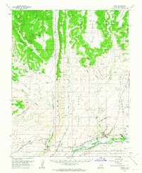 1962 Bluff1963 Print · USGSThe high desert landscape around the San Juan River comes into focus in the early sixties, showing the settlement of Bluff and the surrounding mesas. Historians can trace the Mormon Road and locate numerous cliff dwellings and the St Christophers Mission.3 unique versions available
 - 1966 Map of Cortez
 1966 Cortez1966 Print · USGSThe Four Corners region in the mid-sixties reveals a landscape of high mesas, tribal lands, and archaeological preserves. Researchers can trace the ancient sites at Hovenweep National Monument, follow the Denver & Rio Grande Western Railroad, or locate old settlements like Ginger Hill and Yellow Jacket.
 - 1983 Map of Bluff
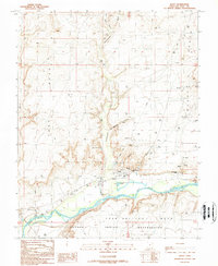
 1983 Bluff1983 Print · USGSThe San Juan River country in the early 1980s reveals a landscape of high mesas and indigenous settlements. Trace the rugged terrain of Comb Ridge, locate the Hatch Trading Post, and explore the roads connecting Bluff to Mexican Hat.2 unique versions available
 - 1989 Map of Bluff
 1989 Bluff1989 Print · USGSBluff and the northern edge of the Navajo lands are shown here in the late 1980s as the river-bound community maintains its desert footprint. Genealogists and historians can locate the St Christophers Mission, the local Cem, and iconic landmarks like the Navajo Twins.2 unique versions available
 - 1997 Map of Bluff, 2002 Print
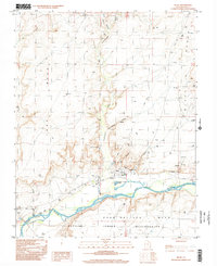 1997 Bluff2002 Print · USGSThe community of Bluff and the surrounding canyonlands appear here in the late nineties as a landscape of red-rock mesas and river-bottom mission life. Researchers can trace the San Juan River corridor, the St Christophers Mission, and landmarks like the Navajo Twins.
End of results
Showing maps 1-9 of 9
Top cities near Bluff
Frequently asked questions
- What are the different types of historical maps available for Bluff?
- What is the oldest map of Bluff?
- Where can I purchase historical maps of Bluff for my home or office?
- Where can I download high-res historical maps of Bluff?
- Are there historical topographic maps available for Bluff?
- Is there historical aerial imagery available for Bluff?
- Where are historical maps of Bluff sourced from?