1980s Maps of Spanish Valley, Utah
Explore 3 historic maps of Spanish Valley from the 1980s. These maps offer a rare glimpse into what life looked like during the 1980s — showing old roads, neighborhoods, homes, and landmarks that have changed or disappeared over time.
Whether you're researching your family's past, planning a metal detecting trip, or studying how Spanish Valley's landscape evolved across the 1980s, these high-resolution maps are a powerful tool for exploring the history of this region.
- Focus on a specific era: All maps on this page are from the 1980s, giving you a focused view of this time period.
- See what’s changed: Compare century-old streets, trails, and buildings to today's modern landscape using overlays and satellite layers.
- Research with precision: Use these maps for genealogy, historical research, land use analysis, or educational projects.
- View, download, or print: Maps are fully viewable online in high resolution, and can be downloaded or printed for your own records.
Start exploring Spanish Valley's history through authentic maps from the 1980s. This is your window into the past.
Spanish Valley, UT maps
(3)- 1982 Map of La Sal, 1983 Print
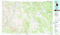 1982 La Sal1983 Print · USGSThe high desert of southeastern Utah meets the Colorado border in the early eighties, showing a landscape defined by deep canyons and mining. Trace the industrial operations at Lisbon Mine or explore the early mapping of The Needles and Island in the Sky.2 unique versions available
 - 1987 Map of Mount Tukuhnikivatz
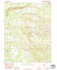 1987 Mount Tukuhnikivatz1987 Print · USGSThe high peaks of the La Sal Mountains are captured in the late twentieth century, showing a remote landscape of mining prospects and alpine basins. Researchers can trace historic access routes through La Sal Pass and locate early mineral work at Gold Basin or Slaughter Flats.2 unique versions available
 - 1987 Map of Kane Springs
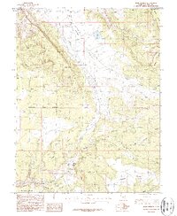 1987 Kane Springs1987 Print · USGSSan Juan County and the southern edge of the Moab area are captured here in the late eighties, showing the transition from valley floor to high mesa. Trace local landmarks like the Kane Springs Roadside Park, Kens Lake, and the expansive Behind the Rocks terrain.2 unique versions available
End of results
Showing maps 1-3 of 3
Top cities near Spanish Valley
Frequently asked questions
- What are the different types of historical maps available for Spanish Valley?
- What is the oldest map of Spanish Valley?
- Where can I purchase historical maps of Spanish Valley for my home or office?
- Where can I download high-res historical maps of Spanish Valley?
- Are there historical topographic maps available for Spanish Valley?
- Is there historical aerial imagery available for Spanish Valley?
- Where are historical maps of Spanish Valley sourced from?