1990s Maps of Francis, Utah
Explore 3 historic maps of Francis from the 1990s. These maps offer a rare glimpse into what life looked like during the 1990s — showing old roads, neighborhoods, homes, and landmarks that have changed or disappeared over time.
Whether you're researching your family's past, planning a metal detecting trip, or studying how Francis's landscape evolved across the 1990s, these high-resolution maps are a powerful tool for exploring the history of this region.
- Focus on a specific era: All maps on this page are from the 1990s, giving you a focused view of this time period.
- See what’s changed: Compare century-old streets, trails, and buildings to today's modern landscape using overlays and satellite layers.
- Research with precision: Use these maps for genealogy, historical research, land use analysis, or educational projects.
- View, download, or print: Maps are fully viewable online in high resolution, and can be downloaded or printed for your own records.
Start exploring Francis's history through authentic maps from the 1990s. This is your window into the past.
Francis, UT maps
(3)- 1997 Map of Francis, 2001 Print
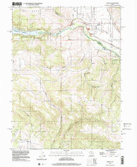 1997 Francis2001 Print · USGSRhodes Valley and the upper Provo River region are captured here in the late nineties, showcasing a landscape shaped by water and high-mountain terrain. You can trace the development of Francis, locate the local Cem, and explore the shoreline of Jordanelle Reservoir.
 - 1998 Map of Kamas, 2001 Print
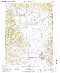 1998 Kamas2001 Print · USGSKamas Valley was a bustling hub of agriculture and water management in the late nineties, positioned right against the national forest. Genealogists can locate family names at Oakley Cem or Stevens Cem, while others can trace the Provo River Diversion Canal and the grounds of the South Summit High Sch.
 - 1998 Map of Woodland, 2001 Print
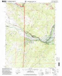 1998 Woodland2001 Print · USGSThe high valleys of the Provo River corridor are captured here during the late 1990s as the area balanced mountain settlement with forest management. Researchers can find family landmarks like Potters Knoll, the local Cem, and recreation sites such as Oakcrest Camp.
End of results
Showing maps 1-3 of 3
Top cities near Francis
- Heber City historical maps
- Park City historical maps
- Midway historical maps
- Kamas historical maps
- Oakley historical maps
- Charleston historical maps
See more
Frequently asked questions
- What are the different types of historical maps available for Francis?
- What is the oldest map of Francis?
- Where can I purchase historical maps of Francis for my home or office?
- Where can I download high-res historical maps of Francis?
- Are there historical topographic maps available for Francis?
- Is there historical aerial imagery available for Francis?
- Where are historical maps of Francis sourced from?