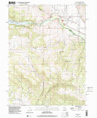
1997 Map of Francis
USGS Topo · Published 2001About this map
Rhodes Valley serves as the primary setting for the high-country settlement of Francis, positioned along the transition between the basin and the surrounding uplands. The landscape is defined by the recently filled Jordanelle Reservoir and its associated Jordanelle State Park, which altered the historical flow of the Provo River. This era of the late 1990s shows the region's shift toward recreation and water management, while maintaining traces of older land uses such as the Quarry near the river and a Mine tucked into Webb Hollow. To the south, the terrain becomes increasingly complex, characterized by steep drainage systems like Little Pole Canyon and Big Pole Canyon that cut through the ridges. Infrastructure like the Canal and several Pipeline segments crisscross the valley floor, highlighting the vital role of water distribution in this part of Summit and Wasatch Counties.
Find a feature on this map
27 named features on this map. Tap any name to fly to it.
Don’t see what you’re looking for? This feature index may not catch every label — zoom into the map to look around manually.
Map Details
Editions of this 1997 Francis Map
This is the sole edition of this map. No revisions or reprints were ever made.
Other maps of this area

1885 · Salt Lake
USGS Topo · 1:250,000

1900 · Coalville
USGS Topo · 1:125,000

1903 · Coalville
USGS Topo · 1:125,000

1907 · Strawberry Valley
USGS Topo · 1:125,000

1909 · Strawberry Valley
USGS Topo · 1:125,000

1954 · Salt Lake City
USGS Topo · 1:250,000

1955 · Heber
USGS Topo · 1:24,000

1955 · Park City East
USGS Topo · 1:24,000

1958 · Salt Lake City
USGS Topo · 1:250,000

1960 · Salt Lake City
USGS Topo · 1:250,000