1960 Map of Salt Lake City
USGS Topo · Published 1960About this map
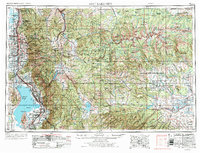
Salt Lake City and the expanding valley corridor define the western edge of this mid-century landscape, where urban growth follows the base of the Wasatch Range. The map reveals the industrial and infrastructure backbone of the region, from the massive Bingham Canyon Mine in the Oquirrh Mountains to the concentration of settlements like Murray, Midvale, and Sandy. To the east, the high wilderness of the Uinta Mountains dominates, featuring Kings Peak and the headwaters of the Duchesne River and Uinta River. Water management is a central theme, evidenced by the Strawberry Reservoir, Echo Reservoir, and the Lake Fork Canal systems within the Uinta and Ouray Indian Reservation. This survey captures the transition from the dense Mormon Corridor along Utah Lake to the protected timberlands of the Wasatch National Forest and Ashley National Forest.
Find a feature on this map
248 named features on this map. Tap any name to fly to it.
Don’t see what you’re looking for? This feature index may not catch every label — zoom into the map to look around manually.
Map Details
Editions of this 1960 Salt Lake City Map
This is the sole edition of this map. No revisions or reprints were ever made.
Historical Maps of Salt Lake City Through Time
4 maps found