1960s Maps of Cedar Fort, Utah
Explore 3 historic maps of Cedar Fort from the 1960s. These maps offer a rare glimpse into what life looked like during the 1960s — showing old roads, neighborhoods, homes, and landmarks that have changed or disappeared over time.
Whether you're researching your family's past, planning a metal detecting trip, or studying how Cedar Fort's landscape evolved across the 1960s, these high-resolution maps are a powerful tool for exploring the history of this region.
- Focus on a specific era: All maps on this page are from the 1960s, giving you a focused view of this time period.
- See what’s changed: Compare century-old streets, trails, and buildings to today's modern landscape using overlays and satellite layers.
- Research with precision: Use these maps for genealogy, historical research, land use analysis, or educational projects.
- View, download, or print: Maps are fully viewable online in high resolution, and can be downloaded or printed for your own records.
Start exploring Cedar Fort's history through authentic maps from the 1960s. This is your window into the past.
Cedar Fort, UT maps
(3)- 1968 Map of Mercur, 1970 Print
 1968 Mercur1970 Print · USGSThe Oquirrh Mountains mining district comes into sharp focus during the late 1960s, revealing a landscape of industrial extraction and high-altitude settlements. Trace the legacy of gold and silver production at the Geyser Marion Mine or locate the historical footprints of Sunshine (Site) and Manning (Site).2 unique versions available
 - 1968 Map of Cedar Fort, 1970 Print
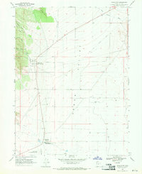 1968 Cedar Fort1970 Print · USGSCedar Valley and the Oquirrh foothills appear here in the late sixties, capturing a landscape deeply rooted in pioneer and military history. Trace the legacy of the Old West at the Stage Coach Inn and find the Old Railroad Grade running through Fairfield.
 - 1968 Map of Lowe Peak, 1971 Print
 1968 Lowe Peak1971 Print · USGSThe Oquirrh Mountains at the end of the sixties reveal a landscape defined by military boundaries and mining history. Trace the high-altitude Old Military Road or locate historical extraction sites like the Old Mayflower Mine and Queen Mine.
End of results
Showing maps 1-3 of 3
Top cities near Cedar Fort
- West Jordan historical maps
- Sandy historical maps
- Lehi historical maps
- South Jordan historical maps
- Eagle Mountain historical maps
- Saratoga Springs historical maps
See more
Frequently asked questions
- What are the different types of historical maps available for Cedar Fort?
- What is the oldest map of Cedar Fort?
- Where can I purchase historical maps of Cedar Fort for my home or office?
- Where can I download high-res historical maps of Cedar Fort?
- Are there historical topographic maps available for Cedar Fort?
- Is there historical aerial imagery available for Cedar Fort?
- Where are historical maps of Cedar Fort sourced from?