1900s (20th Century) Maps of Townsend, Genola
Explore 7 historic maps of Townsend from the 1900s (20th Century). These maps offer a rare glimpse into what life looked like during the 1900s — showing old roads, neighborhoods, homes, and landmarks that have changed or disappeared over time.
Whether you're researching your family's past, planning a metal detecting trip, or studying how Townsend's landscape evolved across the 1900s, these high-resolution maps are a powerful tool for exploring the history of this region.
- Focus on a specific era: All maps on this page are from the 1900s, giving you a focused view of this time period.
- See what’s changed: Compare century-old streets, trails, and buildings to today's modern landscape using overlays and satellite layers.
- Research with precision: Use these maps for genealogy, historical research, land use analysis, or educational projects.
- View, download, or print: Maps are fully viewable online in high resolution, and can be downloaded or printed for your own records.
Start exploring Townsend's history through authentic maps from the 1900s. This is your window into the past.
Townsend, Genola maps
(7)- 1951 Map of Santaquin, 1953 Print
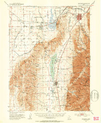 1951 Santaquin1953 Print · USGSThe orchards and rail junctions of central Utah appear here in the early fifties, from the grid of Santaquin to the valley farms of Mona. Researchers can trace the legacy of the Privateer Mine and family landmarks like Lunt-Lattimer Spring and Burriston Ponds.3 unique versions available
 - 1956 Map of Price, 1968 Print
 1956 Price1968 Print · USGSCentral Utah in the mid-fifties showcases a landscape shaped by coal mining and mountain-fed irrigation. Trace the rail-and-river economy through the Geneva Coal Mine, the Union Pacific line, and settlements like Price and Ephraim.3 unique versions available
 - 1960 Map of Price
 1960 Price1960 Print · USGSCentral Utah in the late fifties was a landscape of coal-hauling railroads and high plateau settlements. Genealogists and local historians can trace the rail-to-river economy from Price to the mountain mining camps of Hiawatha, Dragerton, and Sunnyside.2 unique versions available
 - 1962 Map of Price
 1962 Price1962 Print · USGSCentral Utah during the early sixties shows a landscape balancing high-mountain forestry with valley agriculture and coal mining. Genealogists and historians can trace the Denver and Rio Grande Western rail lines through industrial hubs like Price or locate formerly active sites like Coal City (abandoned).
 - 1979 Map of Santaquin, 1984 Print
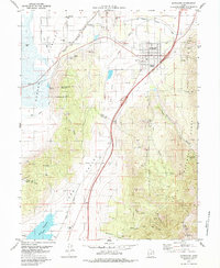 1979 Santaquin1984 Print · USGSSantaquin and the fertile valleys of central Utah are captured in the late seventies as the region balanced its mining heritage with a growing rail-and-water economy. Genealogists and historians can trace the footprint of Genola, local mines in Santaquin Canyon, and the routes of the Union Pacific railroad.
 - 1981 Map of Nephi
 1981 Nephi1981 Print · USGSThe Juab and Sanpete valleys of central Utah are captured here in the early 1980s, during a period of established mountain settlement and rail-based commerce. Researchers can trace the routes of the Union Pacific and visit traditional communities like Nephi, Mount Pleasant, and Scofield.3 unique versions available
 - 1998 Map of Santaquin, 2002 Print
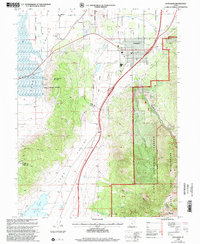 1998 Santaquin2002 Print · USGSThe foothills of the Wasatch Range meet the agricultural fields of Utah and Juab Counties in the late nineties. Local researchers can trace water rights along the Strawberry Highline Canal or explore old mining sites and cemeteries near Santaquin and Genola.
End of results
Showing maps 1-7 of 7
Top cities near Townsend
- Provo historical maps
- Spanish Fork historical maps
- Springville historical maps
- Payson historical maps
- Mapleton historical maps
- Salem historical maps
See more
Frequently asked questions
- What are the different types of historical maps available for Townsend?
- What is the oldest map of Townsend?
- Where can I purchase historical maps of Townsend for my home or office?
- Where can I download high-res historical maps of Townsend?
- Are there historical topographic maps available for Townsend?
- Is there historical aerial imagery available for Townsend?
- Where are historical maps of Townsend sourced from?