1940s Maps of North Timpview, Provo
Explore 3 historic maps of North Timpview from the 1940s. These maps offer a rare glimpse into what life looked like during the 1940s — showing old roads, neighborhoods, homes, and landmarks that have changed or disappeared over time.
Whether you're researching your family's past, planning a metal detecting trip, or studying how North Timpview's landscape evolved across the 1940s, these high-resolution maps are a powerful tool for exploring the history of this region.
- Focus on a specific era: All maps on this page are from the 1940s, giving you a focused view of this time period.
- See what’s changed: Compare century-old streets, trails, and buildings to today's modern landscape using overlays and satellite layers.
- Research with precision: Use these maps for genealogy, historical research, land use analysis, or educational projects.
- View, download, or print: Maps are fully viewable online in high resolution, and can be downloaded or printed for your own records.
Start exploring North Timpview's history through authentic maps from the 1940s. This is your window into the past.
North Timpview, Provo maps
(3)- 1948 Map of Orem, 1957 Print
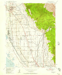 1948 Orem1957 Print · USGSPostwar industrialization and agricultural roots converge in this mid-century survey of the Utah Valley shoreline. Genealogists and local historians can trace the footprint of the Geneva Steel Plant, local schools like Vineyard School, and old settlements such as Christmas City.4 unique versions available
 - 1948 Map of Orem, 1959 Print
 1948 Orem1959 Print · USGSThe Utah Valley at the end of the 1940s showcases a unique blend of heavy industry and high-mountain wilderness. Local historians can trace the development of Orem and Pleasant Grove or locate the Steel Plant and Lincoln Jr HS near Utah Lake.2 unique versions available
 - 1948 Map of Bridal Veil Falls, 1960 Print
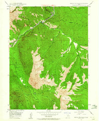 1948 Bridal Veil Falls1960 Print · USGSThe Provo River canyon was a vital transportation corridor just after the war, where the Denver & Rio Grande Western RR wound past steep peaks. Trace early settlement sites and mountain landmarks like Bridal Veil Falls, Vivian Park, and Y Mountain.4 unique versions available
End of results
Showing maps 1-3 of 3
Frequently asked questions
- What are the different types of historical maps available for North Timpview?
- What is the oldest map of North Timpview?
- Where can I purchase historical maps of North Timpview for my home or office?
- Where can I download high-res historical maps of North Timpview?
- Are there historical topographic maps available for North Timpview?
- Is there historical aerial imagery available for North Timpview?
- Where are historical maps of North Timpview sourced from?