1990s Maps of North Timpview, Provo
Explore 4 historic maps of North Timpview from the 1990s. These maps offer a rare glimpse into what life looked like during the 1990s — showing old roads, neighborhoods, homes, and landmarks that have changed or disappeared over time.
Whether you're researching your family's past, planning a metal detecting trip, or studying how North Timpview's landscape evolved across the 1990s, these high-resolution maps are a powerful tool for exploring the history of this region.
- Focus on a specific era: All maps on this page are from the 1990s, giving you a focused view of this time period.
- See what’s changed: Compare century-old streets, trails, and buildings to today's modern landscape using overlays and satellite layers.
- Research with precision: Use these maps for genealogy, historical research, land use analysis, or educational projects.
- View, download, or print: Maps are fully viewable online in high resolution, and can be downloaded or printed for your own records.
Start exploring North Timpview's history through authentic maps from the 1990s. This is your window into the past.
North Timpview, Provo maps
(4)- 1993 Map of Bridal Veil Falls, 1994 Print
 1993 Bridal Veil Falls1994 Print · USGSCanyon life in the Wasatch Range was defined by the river and the road during the early 1990s. Trace the development of mountain communities like Vivian Park and Upper Falls alongside recreational landmarks like Bridal Veil Falls and the Sundance Ski Area.
 - 1994 Map of Orem
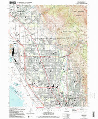 1994 Orem1994 Print · USGSThe Utah Valley landscape is shown here in the mid-1990s as suburban growth reaches the base of Mount Timpanogos. Trace the rail corridors of the Union Pacific, the vast Brigham Young University campus, and the Bunker Grain Elevators.2 unique versions available
 - 1998 Map of Orem, 2000 Print
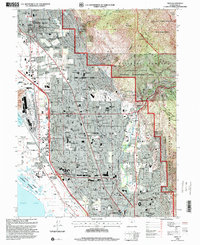 1998 Orem2000 Print · USGSOrem and the surrounding Utah Valley suburbs are shown during a period of rapid growth in the late nineties. Researchers can trace the expansion of Brigham Young University and find landmarks like the Bunker Grain Elevators and Orem Cem.
 - 1998 Map of Bridal Veil Falls, 2000 Print
 1998 Bridal Veil Falls2000 Print · USGSThe Provo River canyon south of Mount Timpanogos appears in the late 1990s as a mix of scenic recreation and essential infrastructure. Explore the canyon's historic character at Vivian Park, the Sundance Ski Area, and the iconic Bridal Veil Falls.
End of results
Showing maps 1-4 of 4
Frequently asked questions
- What are the different types of historical maps available for North Timpview?
- What is the oldest map of North Timpview?
- Where can I purchase historical maps of North Timpview for my home or office?
- Where can I download high-res historical maps of North Timpview?
- Are there historical topographic maps available for North Timpview?
- Is there historical aerial imagery available for North Timpview?
- Where are historical maps of North Timpview sourced from?