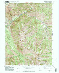
1993 Map of Bridal Veil Falls
USGS Topo · Published 1994About this map
The Provo River carves a deep path through the heart of the Uinta National Forest, serving as the primary corridor for both infrastructure and recreation in this part of the Wasatch Range. Small clusters of mountain settlements like Wildwood, Vivian Park, and Springdell dot the canyon floor, while the Salt Lake City Aqueduct traces the contours of the slopes, highlighting the vital role of this watershed in supporting the region. The landscape is dominated by the massive presence of Mount Timpanogos and Cascade Mountain, creating the steep, vertical drops that feed the iconic Bridal Veil Falls. High-altitude features such as the Sundance Ski Area and the Mount Timpanogos Wilderness indicate a shift toward leisure and conservation, while a network of pack trails and early access points like Hope Campground provide a glimpse into how the backcountry was navigated in the late 20th century.
Find a feature on this map
54 named features on this map. Tap any name to fly to it.
Don’t see what you’re looking for? This feature index may not catch every label — zoom into the map to look around manually.
Map Details
Editions of this 1993 Bridal Veil Falls Map
This is the sole edition of this map. No revisions or reprints were ever made.
Other maps of this area

1885 · Salt Lake
USGS Topo · 1:250,000

1907 · Strawberry Valley
USGS Topo · 1:125,000

1909 · Strawberry Valley
USGS Topo · 1:125,000

1948 · Timpanogos Cave
USGS Topo · 1:24,000

1948 · Orem
USGS Topo · 1:24,000

1948 · Orem
USGS Topo · 1:62,500

1948 · Springville
USGS Topo · 1:24,000

1948 · Aspen Grove
USGS Topo · 1:24,000

1948 · Provo
USGS Topo · 1:24,000

1948 · Bridal Veil Falls
USGS Topo · 1:24,000