1990s Maps of Saratoga Resort, Saratoga Springs
Explore 2 historic maps of Saratoga Resort from the 1990s. These maps offer a rare glimpse into what life looked like during the 1990s — showing old roads, neighborhoods, homes, and landmarks that have changed or disappeared over time.
Whether you're researching your family's past, planning a metal detecting trip, or studying how Saratoga Resort's landscape evolved across the 1990s, these high-resolution maps are a powerful tool for exploring the history of this region.
- Focus on a specific era: All maps on this page are from the 1990s, giving you a focused view of this time period.
- See what’s changed: Compare century-old streets, trails, and buildings to today's modern landscape using overlays and satellite layers.
- Research with precision: Use these maps for genealogy, historical research, land use analysis, or educational projects.
- View, download, or print: Maps are fully viewable online in high resolution, and can be downloaded or printed for your own records.
Start exploring Saratoga Resort's history through authentic maps from the 1990s. This is your window into the past.
Saratoga Resort, Saratoga Springs maps
(2)- 1994 Map of Saratoga Springs
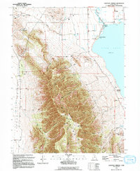 1994 Saratoga Springs1994 Print · USGSThe northern tip of Utah Lake and the Lake Mountains are shown here in the mid-nineties during a time of significant hydrological and land-use shifts. Researchers can locate the Dugout Pony Express Station (Site), trace an Old Railroad Grade, and find early recreation spots like the Hot Springs.
 - 1997 Map of Saratoga Springs, 2001 Print
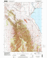 1997 Saratoga Springs2001 Print · USGSThe northwestern shores of Utah Lake come into focus in the late nineties as development begins to meet historic transit routes. Trace the path of the Utah Railroad or locate the Dugout Pony Express Station (Site) and Hot Springs.
End of results
Showing maps 1-2 of 2
Top cities near Saratoga Resort
- West Jordan historical maps
- Provo historical maps
- Orem historical maps
- Sandy historical maps
- Lehi historical maps
- South Jordan historical maps
See more
Frequently asked questions
- What are the different types of historical maps available for Saratoga Resort?
- What is the oldest map of Saratoga Resort?
- Where can I purchase historical maps of Saratoga Resort for my home or office?
- Where can I download high-res historical maps of Saratoga Resort?
- Are there historical topographic maps available for Saratoga Resort?
- Is there historical aerial imagery available for Saratoga Resort?
- Where are historical maps of Saratoga Resort sourced from?