1990s Maps of Timber Lakes, Utah
Explore 2 historic maps of Timber Lakes from the 1990s. These maps offer a rare glimpse into what life looked like during the 1990s — showing old roads, neighborhoods, homes, and landmarks that have changed or disappeared over time.
Whether you're researching your family's past, planning a metal detecting trip, or studying how Timber Lakes's landscape evolved across the 1990s, these high-resolution maps are a powerful tool for exploring the history of this region.
- Focus on a specific era: All maps on this page are from the 1990s, giving you a focused view of this time period.
- See what’s changed: Compare century-old streets, trails, and buildings to today's modern landscape using overlays and satellite layers.
- Research with precision: Use these maps for genealogy, historical research, land use analysis, or educational projects.
- View, download, or print: Maps are fully viewable online in high resolution, and can be downloaded or printed for your own records.
Start exploring Timber Lakes's history through authentic maps from the 1990s. This is your window into the past.
Timber Lakes, UT maps
(2)- 1993 Map of Heber Mountain
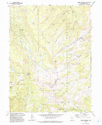 1993 Heber Mountain1993 Print · USGSHigh in the Wasatch Range in the early 1990s, this area shows a landscape defined by federal forests and tribal lands. Researchers can trace historic trails and boundaries between Heber Mountain, the Uinta and Ouray Reservation, and Timber Lakes.
 - 1998 Map of Heber Mountain, 2002 Print
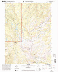 1998 Heber Mountain2002 Print · USGSHigh in the Wasatch Range during the late nineties, this survey tracks the boundaries where the Uinta National Forest meets tribal lands. Trace family-named landmarks like Heber Mountain, the residential roads of Timber Lakes, and the high waters of Currant Creek.
End of results
Showing maps 1-2 of 2
Top cities near Timber Lakes
- Heber City historical maps
- Park City historical maps
- Midway historical maps
- Kamas historical maps
- Francis historical maps
- Charleston historical maps
See more
Frequently asked questions
- What are the different types of historical maps available for Timber Lakes?
- What is the oldest map of Timber Lakes?
- Where can I purchase historical maps of Timber Lakes for my home or office?
- Where can I download high-res historical maps of Timber Lakes?
- Are there historical topographic maps available for Timber Lakes?
- Is there historical aerial imagery available for Timber Lakes?
- Where are historical maps of Timber Lakes sourced from?