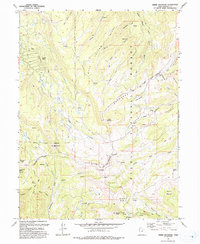
1993 Map of Heber Mountain
USGS Topo · Published 1993About this map
Heber Mountain stands as the central high point of this terrain within the Uinta National Forest, where high-altitude ridges and deep canyons define the headwaters of several major drainages. The Uinta and Ouray Indian Reservation Boundary cuts through the southern and eastern portions of the sheet, marking a significant transition in land management and historical boundary lines. In the northwest, the development of Timber Lakes represents a late 20th-century mountain settlement pattern, contrasted by the surrounding wilderness of Bald Knoll and Buck Basin.
Find a feature on this map
39 named features on this map. Tap any name to fly to it.
Don’t see what you’re looking for? This feature index may not catch every label — zoom into the map to look around manually.
Map Details
Editions of this 1993 Heber Mountain Map
This is the sole edition of this map. No revisions or reprints were ever made.
Other maps of this area

1885 · Salt Lake
USGS Topo · 1:250,000

1900 · Coalville
USGS Topo · 1:125,000

1903 · Coalville
USGS Topo · 1:125,000

1907 · Strawberry Valley
USGS Topo · 1:125,000

1909 · Strawberry Valley
USGS Topo · 1:125,000

1954 · Salt Lake City
USGS Topo · 1:250,000

1958 · Salt Lake City
USGS Topo · 1:250,000

1960 · Salt Lake City
USGS Topo · 1:250,000

1967 · Francis
USGS Topo · 1:24,000
1967 · Center Creek
USGS Topo · 1:24,000