1990s Maps of Huntsville Hollow, Utah
Explore 2 historic maps of Huntsville Hollow from the 1990s. These maps offer a rare glimpse into what life looked like during the 1990s — showing old roads, neighborhoods, homes, and landmarks that have changed or disappeared over time.
Whether you're researching your family's past, planning a metal detecting trip, or studying how Huntsville Hollow's landscape evolved across the 1990s, these high-resolution maps are a powerful tool for exploring the history of this region.
- Focus on a specific era: All maps on this page are from the 1990s, giving you a focused view of this time period.
- See what’s changed: Compare century-old streets, trails, and buildings to today's modern landscape using overlays and satellite layers.
- Research with precision: Use these maps for genealogy, historical research, land use analysis, or educational projects.
- View, download, or print: Maps are fully viewable online in high resolution, and can be downloaded or printed for your own records.
Start exploring Huntsville Hollow's history through authentic maps from the 1990s. This is your window into the past.
Huntsville Hollow, UT maps
(2)- 1991 Map of Browns Hole
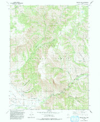 1991 Browns Hole1991 Print · USGSThe high canyons of Weber County are documented here in the early nineties, centered on the South Fork Ogden River drainage. Trace the developed recreational landscape of Cache National Forest through sites like Camp Red Cliff and Willows Campground.
 - 1998 Map of Browns Hole, 2000 Print
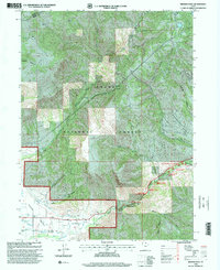 1998 Browns Hole2000 Print · USGSThe eastern reaches of Weber County come into focus in the late nineties, documenting a landscape of forest canyons and valley settlements. Researchers can map out early water infrastructure and recreation sites like the Diversion Dam and Magpie Campground.
End of results
Showing maps 1-2 of 2
Top cities near Huntsville Hollow
- Ogden historical maps
- Layton historical maps
- Kaysville historical maps
- South Weber historical maps
- Fruit Heights historical maps
- Morgan historical maps
See more
Frequently asked questions
- What are the different types of historical maps available for Huntsville Hollow?
- What is the oldest map of Huntsville Hollow?
- Where can I purchase historical maps of Huntsville Hollow for my home or office?
- Where can I download high-res historical maps of Huntsville Hollow?
- Are there historical topographic maps available for Huntsville Hollow?
- Is there historical aerial imagery available for Huntsville Hollow?
- Where are historical maps of Huntsville Hollow sourced from?