1990s Maps of Trappers Ridge, Weber County
Explore 2 historic maps of Trappers Ridge from the 1990s. These maps offer a rare glimpse into what life looked like during the 1990s — showing old roads, neighborhoods, homes, and landmarks that have changed or disappeared over time.
Whether you're researching your family's past, planning a metal detecting trip, or studying how Trappers Ridge's landscape evolved across the 1990s, these high-resolution maps are a powerful tool for exploring the history of this region.
- Focus on a specific era: All maps on this page are from the 1990s, giving you a focused view of this time period.
- See what’s changed: Compare century-old streets, trails, and buildings to today's modern landscape using overlays and satellite layers.
- Research with precision: Use these maps for genealogy, historical research, land use analysis, or educational projects.
- View, download, or print: Maps are fully viewable online in high resolution, and can be downloaded or printed for your own records.
Start exploring Trappers Ridge's history through authentic maps from the 1990s. This is your window into the past.
Trappers Ridge, Weber County maps
(2)- 1991 Map of Huntsville, 1992 Print
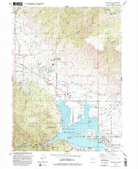 1991 Huntsville1992 Print · USGSThe Ogden Valley was a hub of mountain recreation and agricultural water management in the early nineties. Genealogists and local historians can trace the foundations of Huntsville and Eden, and locate family sites near Mountain View Cemetery and Liberty.
 - 1998 Map of Huntsville, 2001 Print
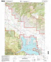 1998 Huntsville2001 Print · USGSOgden Valley in the late nineties is a landscape of mountain peaks and water management centered on the rising waters of the Pineview Reservoir. Genealogists and historians can trace family plots at Mountain View Cemetery or follow the path of the Union Pacific Railroad (Abandoned) through the valley floor.
End of results
Showing maps 1-2 of 2
Frequently asked questions
- What are the different types of historical maps available for Trappers Ridge?
- What is the oldest map of Trappers Ridge?
- Where can I purchase historical maps of Trappers Ridge for my home or office?
- Where can I download high-res historical maps of Trappers Ridge?
- Are there historical topographic maps available for Trappers Ridge?
- Is there historical aerial imagery available for Trappers Ridge?
- Where are historical maps of Trappers Ridge sourced from?