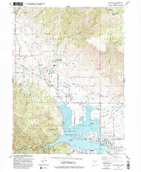
1991 Map of Huntsville
USGS Topo · Published 1992About this map
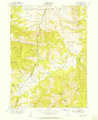
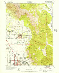
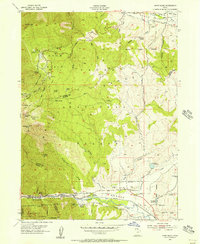
Pineview Reservoir dominates the heart of the Ogden Valley, serving as a focal point for the surrounding agricultural and recreational landscape. The map details the historical layout of Huntsville, Eden, and Liberty as they appeared in the early 1990s, when the valley's character was defined by a mix of traditional ranching and burgeoning mountain tourism. Water management is meticulously documented through features like the Ogden Valley Canal and Huntsville South Ditch, alongside numerous siphons and flumes that channel the North Fork and Middle Fork Ogden Rivers toward the reservoir. Beyond the valley floor, the landscape rises into the Cache National Forest, where resource extraction and recreation meet at the Shanghai Creek No. 1 Mine and the Nordic Valley and Powder Mountain Ski Areas. Small local landmarks, such as Snowcrest High School and Mountain View Cemetery, provide essential anchor points for genealogists and local historians.
Find a feature on this map
60 named features on this map. Tap any name to fly to it.
Don’t see what you’re looking for? This feature index may not catch every label — zoom into the map to look around manually.
Map Details
Editions of this 1991 Huntsville Map
This is the sole edition of this map. No revisions or reprints were ever made.
Other maps of this area

1954 · Ogden
USGS Topo · 1:250,000
1955 · Ogden
USGS Topo · 1:24,000
1955 · Mantua
USGS Topo · 1:24,000
1955 · Huntsville
USGS Topo · 1:24,000
1955 · James Peak
USGS Topo · 1:24,000
1955 · North Ogden
USGS Topo · 1:24,000
1955 · Snow Basin
USGS Topo · 1:24,000

1958 · Ogden
USGS Topo · 1:250,000

1960 · Ogden
USGS Topo · 1:250,000

1961 · Morgan
USGS Topo · 1:62,500