
1961 Map of Morgan
USGS Topo · Published 1963About this map
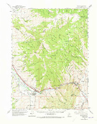
The Weber River valley dominates this early 1960s landscape, serving as the primary corridor for the Union Pacific railroad and the region's agricultural infrastructure. The town of Morgan functions as a central hub, flanked by smaller communities like Milton, Littleton, and Richville. Industrial activity is evident along the riverbanks, particularly at the Cement Plant near the geologic landmark of Devils Slide. Water management for the valley's farms is documented through the Stoddard Canal and Stoddard Diversion Dam. Away from the river, the terrain rises into the Wasatch National Forest, where high peaks such as Durst Mtn and Big Mahogany Mtn overlook numerous canyons. To the north, a Monastery sits in the quiet foothills of Ogden Valley, while recreational and community landmarks like Como Springs and the County Fairgrounds highlight the social geography of the era.
Find a feature on this map
84 named features on this map. Tap any name to fly to it.
Don’t see what you’re looking for? This feature index may not catch every label — zoom into the map to look around manually.
Map Details
Editions of this 1961 Morgan Map
2 editions found
Other maps of this area

1885 · Salt Lake
USGS Topo · 1:250,000

1900 · Coalville
USGS Topo · 1:125,000

1903 · Coalville
USGS Topo · 1:125,000

1925 · Ft. Douglas
USGS Topo · 1:125,000

1928 · Ft. Douglas
USGS Topo · 1:125,000

1952 · Bountiful Peak
USGS Topo · 1:24,000

1954 · Salt Lake City
USGS Topo · 1:250,000

1954 · Ogden
USGS Topo · 1:250,000

1955 · Peterson
USGS Topo · 1:24,000

1955 · Huntsville
USGS Topo · 1:24,000