1940s Maps of Ripton, Vermont
Explore 2 historic maps of Ripton from the 1940s. These maps offer a rare glimpse into what life looked like during the 1940s — showing old roads, neighborhoods, homes, and landmarks that have changed or disappeared over time.
Whether you're researching your family's past, planning a metal detecting trip, or studying how Ripton's landscape evolved across the 1940s, these high-resolution maps are a powerful tool for exploring the history of this region.
- Focus on a specific era: All maps on this page are from the 1940s, giving you a focused view of this time period.
- See what’s changed: Compare century-old streets, trails, and buildings to today's modern landscape using overlays and satellite layers.
- Research with precision: Use these maps for genealogy, historical research, land use analysis, or educational projects.
- View, download, or print: Maps are fully viewable online in high resolution, and can be downloaded or printed for your own records.
Start exploring Ripton's history through authentic maps from the 1940s. This is your window into the past.
Ripton, VT maps
(2)- 1944 Map of East Middlebury
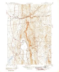 1944 East Middlebury1944 Print · USGSThe Green Mountains in the mid-1940s reveal a landscape of deep timber and valley settlements. Genealogists and hikers can trace old family burial grounds at Prospect Cem and Galvin Cem, or follow the historic path of the Leicester Hollow Trl.6 unique versions available
 - 1946 Map of East Middlebury
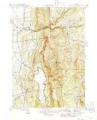 1946 East Middlebury1946 Print · USGSAddison County in the mid-1940s reveals a landscape of mountain hamlets and forest reserves. Genealogists can locate family burial plots at Prospect Cem and Cooks Cem or trace the early community at Satans Kingdom.
End of results
Showing maps 1-2 of 2
Top cities near Ripton
- Middlebury historical maps
- Northfield historical maps
- Brandon historical maps
- Ferrisburgh historical maps
- Warren historical maps
- Bristol historical maps
See more
Top neighborhoods of Ripton
Frequently asked questions
- What are the different types of historical maps available for Ripton?
- What is the oldest map of Ripton?
- Where can I purchase historical maps of Ripton for my home or office?
- Where can I download high-res historical maps of Ripton?
- Are there historical topographic maps available for Ripton?
- Is there historical aerial imagery available for Ripton?
- Where are historical maps of Ripton sourced from?