1990s Maps of Starksboro, Vermont
Explore 2 historic maps of Starksboro from the 1990s. These maps offer a rare glimpse into what life looked like during the 1990s — showing old roads, neighborhoods, homes, and landmarks that have changed or disappeared over time.
Whether you're researching your family's past, planning a metal detecting trip, or studying how Starksboro's landscape evolved across the 1990s, these high-resolution maps are a powerful tool for exploring the history of this region.
- Focus on a specific era: All maps on this page are from the 1990s, giving you a focused view of this time period.
- See what’s changed: Compare century-old streets, trails, and buildings to today's modern landscape using overlays and satellite layers.
- Research with precision: Use these maps for genealogy, historical research, land use analysis, or educational projects.
- View, download, or print: Maps are fully viewable online in high resolution, and can be downloaded or printed for your own records.
Start exploring Starksboro's history through authentic maps from the 1990s. This is your window into the past.
Starksboro, VT maps
(2)- 1997 Map of Bristol, 2000 Print
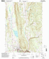 1997 Bristol2000 Print · USGSSettlement in the Green Mountain foothills is captured here during the late twentieth century, showing the rural character of Addison County. Researchers can trace family history through a high density of burial sites like Merrill Cemetery and Hallock Cemetery, or locate community landmarks in Bristol and Rocky Dale.
 - 1997 Map of Mount Ellen, 2000 Print
 1997 Mount Ellen2000 Print · USGSVermont's Green Mountains reveal a landscape of high peaks and winter resorts during the late nineties. Genealogists and hikers can trace the Long Trail past high summits to historic burial grounds like Little Ireland Cem and Jerusalem Cem.
End of results
Showing maps 1-2 of 2
Top cities near Starksboro
- Burlington historical maps
- South Burlington historical maps
- Williston historical maps
- Middlebury historical maps
- Shelburne historical maps
- Waterbury historical maps
See more
Top neighborhoods of Starksboro
Frequently asked questions
- What are the different types of historical maps available for Starksboro?
- What is the oldest map of Starksboro?
- Where can I purchase historical maps of Starksboro for my home or office?
- Where can I download high-res historical maps of Starksboro?
- Are there historical topographic maps available for Starksboro?
- Is there historical aerial imagery available for Starksboro?
- Where are historical maps of Starksboro sourced from?