1980s Maps of Chittenden County, Vermont
Explore 6 historic maps of Chittenden County from the 1980s. These maps offer a rare glimpse into what life looked like during the 1980s — showing old roads, neighborhoods, homes, and landmarks that have changed or disappeared over time.
Whether you're researching your family's past, planning a metal detecting trip, or studying how Chittenden County's landscape evolved across the 1980s, these high-resolution maps are a powerful tool for exploring the history of this region.
- Focus on a specific era: All maps on this page are from the 1980s, giving you a focused view of this time period.
- See what’s changed: Compare century-old streets, trails, and buildings to today's modern landscape using overlays and satellite layers.
- Research with precision: Use these maps for genealogy, historical research, land use analysis, or educational projects.
- View, download, or print: Maps are fully viewable online in high resolution, and can be downloaded or printed for your own records.
Start exploring Chittenden County's history through authentic maps from the 1980s. This is your window into the past.
Chittenden County, VT maps
(6)- 1980 Map of Willsboro
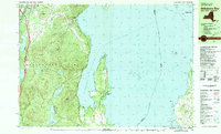
 1980 Willsboro1980 Print · USGSThe Lake Champlain shoreline at the edge of the Adirondacks was a bustling corridor of rail and water transport in the late twentieth century. Researchers can trace the Delaware and Hudson line between Willsboro and Essex, or locate family sites like Brookfield Cem and St Josephs Ch.
 - 1980 Map of Willsboro Bay, 1981 Print
 1980 Willsboro Bay1981 Print · USGSLake Champlain and the eastern edge of the Adirondacks meet in the early eighties, revealing a landscape of shoreline camps and mountain peaks. Trace the Delaware and Hudson rail line through Port Douglass or locate historic family spots near Highlands Forge Lake and Schuyler Island.2 unique versions available
 - 1986 Map of Lake Champlain South
 1986 Lake Champlain South1986 Print · USGSIn the mid-1980s, the shores of Lake Champlain linked the Adirondack high peaks with the Vermont valley. Genealogists and researchers can trace the rail lines of the Delaware & Hudson RR or locate historic settlements like Mineville and Au Sable Forks.2 unique versions available
 - 1986 Map of Lake Champlain North
 1986 Lake Champlain North1986 Print · USGSThe Lake Champlain borderlands in the mid-1980s show a mix of mountain villages and busy island shorelines. Researchers can trace the Delaware and Hudson RR through Plattsburgh or locate old rural sites like Mooers Forks and St Josephs Cem.2 unique versions available
 - 1988 Map of Montpelier
 1988 Montpelier1988 Print · USGSThe area surrounding Vermont’s capital city appears here during the early 1940s, showing the vital rail-and-river network. Genealogists can trace family names across a dozen district schools and rural sites like Middlesex Center and the Talc Mine.2 unique versions available
 - 1989 Map of Mount Mansfield
 1989 Mount Mansfield1989 Print · USGSNorthern Vermont in the late eighties remains a landscape of deep forests and isolated mountain villages. Genealogists and hikers can trace the old rail lines of the Canadian Pacific RR or locate family sites near Lake Willoughby and Brownington Village.
End of results
Showing maps 1-6 of 6
Top cities of Chittenden County
- Burlington historical maps
- South Burlington historical maps
- Colchester historical maps
- Essex historical maps
- Essex Junction historical maps
- Williston historical maps
See more
Frequently asked questions
- What are the different types of historical maps available for Chittenden County?
- What is the oldest map of Chittenden County?
- Where can I purchase historical maps of Chittenden County for my home or office?
- Where can I download high-res historical maps of Chittenden County?
- Are there historical topographic maps available for Chittenden County?
- Is there historical aerial imagery available for Chittenden County?
- Where are historical maps of Chittenden County sourced from?