Old Maps of Chittenden County, Vermont for Metal Detecting
Plan your next treasure hunt with 79 historic maps of Chittenden County. Find old homesites, ghost towns, trails, and gathering spots that may be lost to time — perfect for identifying promising metal detecting locations.
- Locate forgotten sites: Uncover places like long-lost settlements, abandoned rail lines, or gathering spots.
- Plan better hunts: Use map overlays combined with LiDAR or satellite views to narrow in on historically rich areas.
- Made for detectorists: Thousands of hobbyists use these maps to discover relics, coins, and hidden history.
Use these historic maps to boost your research and find new opportunities beneath the surface of Chittenden County.
Chittenden County, VT maps
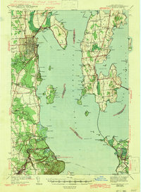
(79)- 1894 Map of Plattsburg
 1894 Plattsburg1894 Print · USGSLake Champlain was a bustling corridor of steamer routes and rail lines in the 1890s. Researchers can trace the layout of Plattsburg Barracks, find the Hotel Champlain at Bluff Point, and explore the islands of GRAND ISLE and South Hero.3 unique versions available
 - 1895 Map of Willsboro
 1895 Willsboro1895 Print · USGSLake Champlain and its late 19th-century transport networks are detailed here, showing the era when ferries and steamships linked New York and Vermont. Genealogists and historians can trace old homesteads and landings near Keeseville, the McNeil Ferry, and the tracks of the Central Vermont R. R.7 unique versions available
 - 1906 Map of Plattsburg
 1906 Plattsburg1906 Print · USGSLake Champlain's northern waters are captured here in the early 1900s, showing the vital maritime and rail corridors of Clinton County and the islands of Vermont. Genealogists and historians can trace the Plattsburg Barracks, find old stops like Grand Isle Sta., and locate lighthouses such as Valcour L.H..6 unique versions available
 - 1906 Map of Burlington
 1906 Burlington1906 Print · USGSBurlington and the Lake Champlain shoreline appear at the height of the railroad era, showing a dense city grid and industrial waterfront. Researchers can locate early schools and burial grounds like the University of Vermont and Greenmount Cemetery, alongside vanished stops like Mechanicsville.7 unique versions available
 - 1913 Map of Milton
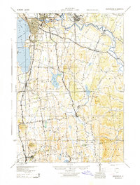
 1913 Milton1913 Print · USGSVermont's northwestern lakefront settlements are captured here just before the Great War, showing a landscape of small school districts and lakeside camps. Trace early transport routes like the CENTRAL VERMONT railroad or locate historic homesites near Miltonborough, Georgia Plains, and Checkerberry Village.
 - 1915 Map of Milton
 1915 Milton1915 Print · USGSNorthwest Vermont's shoreline and interior towns come alive in the decade before the Great War, showing a network of rural schools and lakeside camps. Trace the early layout of Colchester, Westford, and Fort Ethan Allen, or locate family-named sites like Brigham Hill and Bowman Corners.5 unique versions available
 - 1919 Map of Burlington
 1919 Burlington1919 Print · USGSLake Champlain and the Winooski River valley are shown here just after the Great War, during a period of industrial and rail growth. Genealogists can trace family homesteads near Prindle Corners or locate graves at Greenmount Cemetery and Lakeview Cemetery.
 - 1919 Map of Lincoln Mountain, 1953 Print
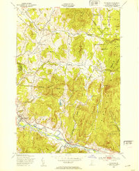
 1919 Lincoln Mountain1953 Print · USGSThe Mad River valley and the high Green Mountain ridges are captured here during the first decades of the twentieth century. Genealogists and historians can locate numerous district schoolhouses like Robinson School and trace the timber-and-rail economy near the Central Vermont line.2 unique versions available
 - 1920 Map of Lincoln Mountain
 1920 Lincoln Mountain1920 Print · USGSThe Green Mountain summits and surrounding hill towns of central Vermont are captured here just after the Great War. Genealogists and local historians can trace old homesteads, early district schools like Gore School, and mountain landmarks such as Battell Lodge.
 - 1921 Map of Richmond
 1921 Richmond1921 Print · USGSThe Green Mountains in the early twenties were defined by the deep valleys of the Winooski River and the high peaks of the northern range. Genealogists and hikers can trace the original footprints of Underhill Center, the Duxbury School, and the Central Vermont rail line.
 - 1921 Map of Lincoln Mountain
 1921 Lincoln Mountain1921 Print · USGSThe Green Mountains in the early twentieth century are seen here in a detailed survey of high-elevation peaks and rural townships. Trace the early Green Mountain Trail past Battell Lodge or locate vanished hillside schoolhouses like Jerusalem School and Alder Hill School.5 unique versions available
 - 1924 Map of Camels Hump
 1924 Camels Hump1924 Print · USGSThe Green Mountains in the early 1920s are centered on the iconic peak of Camels Hump and the busy Winooski River corridor. Genealogists and historians can trace the foundations of local life through the State Hospital for the Insane in Waterbury, small mountain schools like Piddock School, and the path of the Central Vermont railroad.5 unique versions available
 - 1925 Map of Mount Mansfield
 1925 Mount Mansfield1925 Print · USGSNorthern Vermont in the mid-1920s is captured here at the intersection of rail-era commerce and early mountain tourism. Genealogists can trace families through district schools like Governors Right School and landmarks like Morses Mill or Smugglers Notch.
 - 1927 Map of Mount Mansfield
 1927 Mount Mansfield1927 Print · USGSLamoille County and the Green Mountain ridge are captured here in the mid-1920s, showing the height of the valley's rail-and-river era. Genealogists can locate family homesteads near the Irish Settlement, dozens of district schools like Hooper School, and the historic Mt Mansfield Hotel.5 unique versions available
 - 1939 Map of Plattsburg
 1939 Plattsburg1939 Print · USGSLake Champlain was a vital corridor for rail and military activity just before the second World War. Genealogists and historians can trace the Plattsburg Barracks, the Rutland Railroad on Grand Isle, and landmarks like Hotel Champlain.
 - 1941 Map of Plattsburg
 1941 Plattsburg1941 Print · USGSLake Champlain was a critical corridor of military and transport activity in the years leading into the war. Researchers can trace the legacy of the Plattsburg Barracks, the winding Rutland rail line, and the geological site at Ausable Chasm.
 - 1941 Map of Willsboro
 1941 Willsboro1941 Print · USGSLake Champlain's shores in New York and Vermont are captured here just before the war, showing a landscape defined by lakefront landings and busy railroads. Trace the routes of the Delaware and Hudson and find local landmarks like Craterclub, Whallonsburg, and St Josephs Ch.2 unique versions available
 - 1943 Map of Willsboro
 1943 Willsboro1943 Print · USGSThe Lake Champlain shoreline in the early 1940s reveals a landscape of mountain-backed villages and vital cross-lake rail connections. Genealogists and researchers can trace local landmarks like St Josephs Ch, Lakeview Cem, and the path of the Delaware and Hudson railroad.3 unique versions available
 - 1943 Map of Plattsburg
 1943 Plattsburg1943 Print · USGSLake Champlain was a bustling corridor of rail and water traffic in the early 1940s, connecting the Adirondack foothills to the Vermont islands. Genealogists and researchers can trace the old schoolhouses of Beekmantown, the Rutland railroad stops, and historic sites like Hotel Champlain.4 unique versions available
 - 1944 Map of Milton
 1944 Milton1944 Print · USGSThe Lake Champlain shoreline and the Lamoille River valley are captured here just before the mid-forties. Genealogists and local historians can trace rural schoolhouse districts, the grounds of Fort Ethan Allen, and early lakeside retreats like Camp Winisquam.
 - 1944 Map of Mount Mansfield
 1944 Mount Mansfield1944 Print · USGSNorthern Vermont in the mid-1940s is defined here by high mountain peaks and a dense network of rural school districts. Genealogists can trace family footprints through numerous local landmarks like Irish Settlement Sch, Marses Mill, and the high-altitude Mt Mansfield Hotel.
 - 1944 Map of Camels Hump
 1944 Camels Hump1944 Print · USGSThe Green Mountains at the height of the war era show a landscape defined by valley settlements and military expansion. You can trace the Central Vermont rail line through Bolton or find vanished rural schoolhouses like Ricker Sch and Phillips Sch.
 - 1944 Map of Burlington
 1944 Burlington1944 Print · USGSMid-century Burlington and its surrounding Lake Champlain shorelines are captured here at the height of the war years. Local historians can trace the Rutland Railroad through Shelburne or locate family sites near Prindle Corners and Fays Corners.2 unique versions available
 - 1948 Map of Richmond
 1948 Richmond1948 Print · USGSChittenden County rural life and mountain industry are captured here just after the war. Researchers can trace the Central Vermont rail line through Richmond, locate the Old Round Church, and explore the limits of the Fort Ethan Allen Military Reservation.5 unique versions available
 - 1948 Map of Milton, 1953 Print
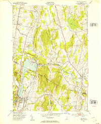 1948 Milton1953 Print · USGSThe Lamoille River valley in the late 1940s shows a landscape of rail-connected villages and rising hills on the Franklin and Chittenden county line. Trace local heritage at Bellows Free Academy, the Central Vermont Railway, and Hope Cem.5 unique versions available
Showing maps 1-25 of 79
Top cities of Chittenden County
- Burlington historical maps
- South Burlington historical maps
- Colchester historical maps
- Essex historical maps
- Essex Junction historical maps
- Williston historical maps
See more
Frequently asked questions
- What are the different types of historical maps available for Chittenden County?
- What is the oldest map of Chittenden County?
- Where can I purchase historical maps of Chittenden County for my home or office?
- Where can I download high-res historical maps of Chittenden County?
- Are there historical topographic maps available for Chittenden County?
- Is there historical aerial imagery available for Chittenden County?
- Where are historical maps of Chittenden County sourced from?