1970s Maps of Topsham, Vermont
Explore 2 historic maps of Topsham from the 1970s. These maps offer a rare glimpse into what life looked like during the 1970s — showing old roads, neighborhoods, homes, and landmarks that have changed or disappeared over time.
Whether you're researching your family's past, planning a metal detecting trip, or studying how Topsham's landscape evolved across the 1970s, these high-resolution maps are a powerful tool for exploring the history of this region.
- Focus on a specific era: All maps on this page are from the 1970s, giving you a focused view of this time period.
- See what’s changed: Compare century-old streets, trails, and buildings to today's modern landscape using overlays and satellite layers.
- Research with precision: Use these maps for genealogy, historical research, land use analysis, or educational projects.
- View, download, or print: Maps are fully viewable online in high resolution, and can be downloaded or printed for your own records.
Start exploring Topsham's history through authentic maps from the 1970s. This is your window into the past.
Topsham, VT maps
(2)- 1973 Map of East Corinth, 1975 Print
 1973 East Corinth1975 Print · USGSThe Orange County hill country comes into focus in the 1970s, showing the enduring rural character of the Waits River valley. Researchers can trace historic family cemeteries like Page Hill Cem and explore remote landmarks such as Iras Pinnacle.
 - 1973 Map of Groton, 1975 Print
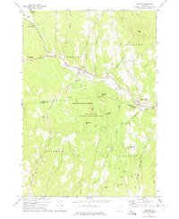 1973 Groton1975 Print · USGSThe Wells River valley in the early 1970s reveals a landscape of upland forests and small mountain settlements. Researchers can trace the Old Railroad Grade past Ricker Mills or locate local burials at Hillside Cem and Pinehurst Cem.
End of results
Showing maps 1-2 of 2
Top cities near Topsham
- Haverhill historical maps
- Williamstown historical maps
- East Montpelier historical maps
- Newbury Village historical maps
- Newbury historical maps
- Calais historical maps
See more
Top neighborhoods of Topsham
- Topsham Four Corners historical maps
- Waits River historical maps
- East Topsham historical maps
- West Topsham historical maps
Frequently asked questions
- What are the different types of historical maps available for Topsham?
- What is the oldest map of Topsham?
- Where can I purchase historical maps of Topsham for my home or office?
- Where can I download high-res historical maps of Topsham?
- Are there historical topographic maps available for Topsham?
- Is there historical aerial imagery available for Topsham?
- Where are historical maps of Topsham sourced from?