1980s Maps of Topsham, Vermont
Explore 3 historic maps of Topsham from the 1980s. These maps offer a rare glimpse into what life looked like during the 1980s — showing old roads, neighborhoods, homes, and landmarks that have changed or disappeared over time.
Whether you're researching your family's past, planning a metal detecting trip, or studying how Topsham's landscape evolved across the 1980s, these high-resolution maps are a powerful tool for exploring the history of this region.
- Focus on a specific era: All maps on this page are from the 1980s, giving you a focused view of this time period.
- See what’s changed: Compare century-old streets, trails, and buildings to today's modern landscape using overlays and satellite layers.
- Research with precision: Use these maps for genealogy, historical research, land use analysis, or educational projects.
- View, download, or print: Maps are fully viewable online in high resolution, and can be downloaded or printed for your own records.
Start exploring Topsham's history through authentic maps from the 1980s. This is your window into the past.
Topsham, VT maps
(3)- 1981 Map of Knox Mountain
 1981 Knox Mountain1981 Print · USGSThe Vermont highlands near Orange and Groton are captured in the early 1980s, showing a landscape shaped by state forests and mountain peaks. Genealogists and hikers can locate Westville Cem, the William Scott Mem Mon, and the Lookout Tower atop Spruce Mtn.2 unique versions available
 - 1981 Map of West Topsham
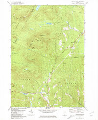
 1981 West Topsham1981 Print · USGSThe hill country of Orange and Topsham in the early 1980s reveals a landscape of isolated valley settlements and high ridges. Genealogists can trace family names at Hutchinson Cem or locate old sites like Union No 36 Sch and the mines on Pike Hill.
 - 1988 Map of Montpelier
 1988 Montpelier1988 Print · USGSThe area surrounding Vermont’s capital city appears here during the early 1940s, showing the vital rail-and-river network. Genealogists can trace family names across a dozen district schools and rural sites like Middlesex Center and the Talc Mine.2 unique versions available
End of results
Showing maps 1-3 of 3
Top cities near Topsham
- Haverhill historical maps
- Williamstown historical maps
- East Montpelier historical maps
- Newbury Village historical maps
- Newbury historical maps
- Calais historical maps
See more
Top neighborhoods of Topsham
- Topsham Four Corners historical maps
- Waits River historical maps
- East Topsham historical maps
- West Topsham historical maps
Frequently asked questions
- What are the different types of historical maps available for Topsham?
- What is the oldest map of Topsham?
- Where can I purchase historical maps of Topsham for my home or office?
- Where can I download high-res historical maps of Topsham?
- Are there historical topographic maps available for Topsham?
- Is there historical aerial imagery available for Topsham?
- Where are historical maps of Topsham sourced from?