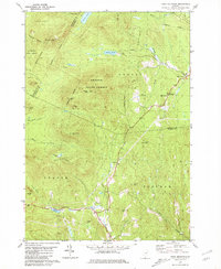
1981 Map of Knox Mountain
USGS Topo · Published 1981About this map
Groton State Forest and L R Jones State Forest dominate this landscape on the border of Washington, Caledonia, and Orange Counties. The terrain is defined by a series of prominent peaks, including Signal Mtn, Knox Mountain, and Spruce Mtn, where a Lookout Tower stands as a focal point for forest management. The drainage network is dense, with headwaters like Nate Smith Brook and Nelson Brook feeding into the Watts River.
Find a feature on this map
40 named features on this map. Tap any name to fly to it.
Don’t see what you’re looking for? This feature index may not catch every label — zoom into the map to look around manually.
Map Details
Editions of this 1981 Knox Mountain Map
2 editions found
Other maps of this area

1931 · Woodsville
USGS Topo · 1:48,000

1935 · Woodsville
USGS Topo · 1:62,500

1938 · St. Johnsbury
USGS Topo · 1:48,000

1939 · Plainfield
USGS Topo · 1:48,000

1940 · Plainfield
USGS Topo · 1:62,500

1941 · Woodsville
USGS Topo · 1:62,500

1943 · Plainfield
USGS Topo · 1:62,500

1943 · St. Johnsbury
USGS Topo · 1:62,500

1947 · Corinth
USGS Topo · 1:62,500

1948 · East Barre
USGS Topo · 1:62,500