
1939 Map of Plainfield
USGS Topo · Published 1939About this map
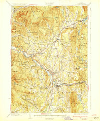
Groton State Forest and the upper Winooski River basin define this landscape just before the 1940s, where three distinct rail lines once served the upland granite and timber economies. The Hardwick & Woodbury RR winds through the northern highlands, while the Montpelier & Wells River RR connects the riverside settlements of Marshfield Sta and Lanesboro. This survey, produced by Elbridge C. Jacobs and the USGS, documents a dense network of local landmarks, from the Old West Ch near Kent Corners to more than a dozen remote schoolhouses like Hollister Hill Sch and Hardwood Flats Sch. High-altitude ponds including Peacham Pond and Nichols Pond punctuate the ridges, illustrating the relationship between the area's water resources and the industrial power house sites found along the river downstream from Cabot.
Find a feature on this map
188 named features on this map. Tap any name to fly to it.
Don’t see what you’re looking for? This feature index may not catch every label — zoom into the map to look around manually.
Map Details
Editions of this 1939 Plainfield Map
This is the sole edition of this map. No revisions or reprints were ever made.
Other maps of this area

1919 · Montpelier
USGS Topo · 1:62,500

1921 · Montpelier
USGS Topo · 1:62,500

1922 · Barre
USGS Topo · 1:48,000

1924 · Barre
USGS Topo · 1:62,500

1927 · Hyde Park
USGS Topo · 1:48,000

1928 · Hardwick
USGS Topo · 1:62,500
1930 · Hyde Park
USGS Topo · 1:62,500

1931 · Woodsville
USGS Topo · 1:48,000

1934 · Hardwick
USGS Topo · 1:48,000

1935 · Woodsville
USGS Topo · 1:62,500