Old Maps of Caledonia County, Vermont
Explore 190 old maps of Caledonia County, spanning from 1924 to today. These high-resolution historic maps reveal how streets, neighborhoods, landmarks, and natural features evolved over time — perfect for genealogy, metal detecting, research, and local history exploration.
What you can do with these maps:
- See how Caledonia County changed over time: Compare historical maps to modern-day views to trace roads, homesites, rail lines & more.
- View detailed metadata: Each map includes creators, publishers, year, scale, and archive source.
- Overlay maps with satellite & LiDAR: Visualize the past alongside modern tools to explore terrain & human change.
- Trusted historical sources: Maps sourced from the USGS, Library of Congress, and other archives.
- Access maps your way: View online, download high-res files, or order prints for personal or research use.
Start exploring old maps of Caledonia County to uncover forgotten places, hidden landmarks, and the deep history beneath your feet.
Caledonia County, VT maps
(190)- 1924 Map of Island Pond
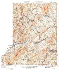
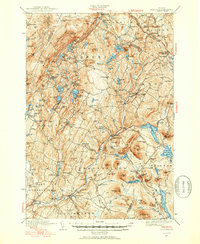
 1924 Island Pond1924 Print · USGSNortheast Kingdom hill towns and isolated rail stops are captured here in the mid-1920s. Genealogists can locate many rural schoolhouses like Bazzinet School and Blake School, or trace the Grand Trunk Railway past Wenlock and Island Pond.
 - 1926 Map of Island Pond
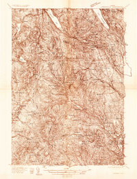
 1926 Island Pond1926 Print · USGSNortheast Vermont during the mid-twenties shows a landscape of timberlands and rail-dependent villages along the Canadian border. Genealogists and researchers can trace local school districts like Buck School or follow the Grand Trunk Railway past Norton Mills.4 unique versions available
 - 1928 Map of Hardwick, 1938 Print
 1928 Hardwick1938 Print · USGSUpper Vermont at the end of the 1920s is seen here through its network of district schools and valley rail lines. Genealogists can trace family landmarks like Jackson Bridge or locate vanished schoolhouses such as Beeler Sch and Speir Sch.
 - 1931 Map of Littleton
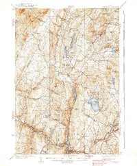
 1931 Littleton1931 Print · USGSUpper Connecticut River Valley life is recorded here in the early thirties, just as aerial photography began to modernize topographic surveying. Genealogists can locate family-named hills and district schools like the Walker Hill Sch and Gilmanton Sch.2 unique versions available
 - 1931 Map of Woodsville
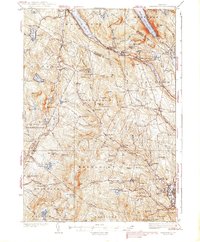
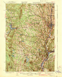
 1931 Woodsville1931 Print · USGSThe Upper Connecticut River Valley in the early 1930s reveals a landscape of riverside rail towns and debated state boundaries. Genealogists and historians can trace the foundations of local life through labels like the North Monroe Ch, Blackmount Sta, and the County Poor Farm.
 - 1932 Map of Littleton
 1932 Littleton1932 Print · USGSThe Upper Connecticut River valley and the hills of Vermont's Northeast Kingdom appear here in the early thirties. Trace family connections through numerous rural schoolhouses like Sugar Hill Sch or locate the old Kirby Mtn Quarries and the original path of the Maine Central Railroad.3 unique versions available
 - 1934 Map of Hardwick
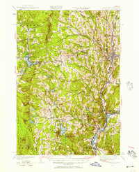
 1934 Hardwick1934 Print · USGSUpper Vermont's hill towns and river valleys are captured here in the mid-1930s, showing a landscape tied to the Lamoille River and small-town industry. Researchers can trace dozens of rural schoolhouses like Collinsville Sch and landmarks such as Jackson Bridge.
 - 1935 Map of Woodsville
 1935 Woodsville1935 Print · USGSThe Connecticut River valley in the mid-1930s is captured here in detail along the Vermont-New Hampshire border. Researchers can trace the legacy of local institutions and transport at the County Poor Farm, the Blackmount Sta rail stop, and The Oxbow.5 unique versions available
 - 1935 Map of Littleton
 1935 Littleton1935 Print · USGSThe Upper Connecticut River Valley comes alive in the mid-1930s, showing the borderlands of Vermont and New Hampshire during a period of hydroelectric and rail expansion. Researchers can trace the legacy of local education and industry through sites like the Kirby Mtn Quarries, the Frank D. Comerford Hydro-Electric Plant, and the Slate Ledge Sch.4 unique versions available
 - 1935 Map of Lyndonville
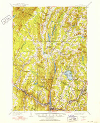
 1935 Lyndonville1935 Print · USGSThe Northeast Kingdom's rail-and-timber era comes to life in this survey of Caledonia County in the mid-1930s. Genealogists and historians can trace the Military Road, identify family plots at the Samuel Drown Burying Ground, and locate vanished rural schoolhouses like Squabble Hollow Sch.
 - 1938 Map of Hardwick
 1938 Hardwick1938 Print · USGSVermont’s northern hills and the Lamoille River valley are shown in the late 1930s, documenting a time when rural schools and the railroad connected the highlands. Trace family roots through sites like Hazen Road Sch, Greensboro Bend, and the ST JOHNSBURY AND LAKE CHAMPLAIN RR.2 unique versions available
 - 1938 Map of St. Johnsbury
 1938 St. Johnsbury1938 Print · USGSNorthern Vermont in the late thirties reveals a landscape of rail-connected valley towns and upland farming districts. Locate old schoolhouses like Stark Sch, trace the St Johnsbury and Lake Champlain RR, and find family landmarks near Harvey Lake.
 - 1939 Map of Lyndonville
 1939 Lyndonville1939 Print · USGSUpper Caledonia and Orleans Counties are shown in high detail during the late thirties, when the Canadian Pacific railroad still defined the local economy. Genealogists can trace family roots through dozens of rural landmarks, including Glover Cem, South Wheelock Ch, and several dozen local schoolhouses like Old Red Sch.3 unique versions available
 - 1939 Map of Plainfield
 1939 Plainfield1939 Print · USGSVermont's granite-and-timber country is captured here on the eve of the 1940s, when remote rail lines still connected upland villages. Genealogists can trace family names at the Old West Ch, Hollister Hill Sch, and the isolated Lanesboro rail stop.
 - 1940 Map of Plainfield, 1953 Print
 1940 Plainfield1953 Print · USGSVermont's hill country is captured here just before the war, showing a landscape defined by small farms and upland schools. Genealogists can locate family landmarks at Maple Cors Calais PO, Old West Ch, and the St Johnsbury and Lake Champlain RR.2 unique versions available
 - 1941 Map of Woodsville
 1941 Woodsville1941 Print · USGSThe Connecticut River valley was a bustling corridor of granite quarries and rail junctions just before the war. You can trace the legacy of local industry and education through landmarks like Gibson Quarry, the County Poor Farm, and Town Farm Sch.4 unique versions available
 - 1943 Map of Plainfield
 1943 Plainfield1943 Print · USGSVermont's highland farming and rail communities are captured here in the 1940s as the state's rural landscape remained densely settled. Genealogists can locate family-named landmarks like Hollister Hill Sch, trace the Montpelier and Wells River RR, or find the Old West Ch near Kent Cors.2 unique versions available
 - 1943 Map of St. Johnsbury
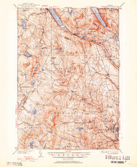
 1943 St. Johnsbury1943 Print · USGSUpper Vermont and New Hampshire communities thrive along the Connecticut and Passumpsic rivers during the early war years. Genealogists can trace family names at Walden Four Corners, find rural schoolhouses like Stanton Sch, or locate the Goslants Mill site.3 unique versions available
 - 1947 Map of Corinth
 1947 Corinth1947 Print · USGSThe granite quarrying region of Vermont is captured here just after the war, showing the industrial density of the hills. Genealogists can trace family roots through numerous local landmarks like Wilson Cem, Miles Sch, and settlements such as Goose Green and Websterville.
 - 1948 Map of East Barre
 1948 East Barre1948 Print · USGSCentral Vermont's quarrying and timber lands are captured here just after the war, showing the industrial centers of the Knox Mountains area. Genealogists can trace family roots through numerous remote burial grounds like Hutchinson Cem and schoolhouses such as Quarry Sch.2 unique versions available
 - 1949 Map of St. Johnsbury, 1957 Print
 1949 St. Johnsbury1957 Print · USGSCaledonia County and the upper Connecticut River valley are captured here just after the war, showing a landscape defined by rail and river. Genealogists and local historians can locate early landmarks like Walden Four Corners, the Frank D Comerford Hydro-electric Plant, and the historic Hazen Road.3 unique versions available
 - 1950 Map of Lake Champlain
 1950 Lake Champlain1950 Print · USGSThe Lake Champlain valley and its surrounding peaks are captured in detail during the late 1940s, showing the vital rail and road connections between New York and Vermont. Researchers can trace the routes of the Central Vermont Railway or locate old industrial centers like Mineville and Witherbee.2 unique versions available
 - 1950 Map of Lewiston
 1950 Lewiston1950 Print · USGSThe Maine and New Hampshire borderlands come alive in this post-war survey of the White Mountains and Androscoggin valley. Genealogists and historians can trace rail lines like the Maine Central Railroad and find high-altitude landmarks from Mount Washington to Bretton Woods.2 unique versions available
 - 1951 Map of Lyndonville
 1951 Lyndonville1951 Print · USGSCaledonia and Orleans counties are shown here in the mid-twentieth century, featuring the deep glacial waters of the Northeast Kingdom. Genealogists and historians can trace local landmarks like Lyndon Teachers College, the Canadian Pacific line through Sutton Sta, and the West Look Cem.5 unique versions available
 - 1951 Map of Hardwick, 1952 Print
 1951 Hardwick1952 Print · USGSThe Northeast Kingdom's rugged highlands and river valleys are captured here in the early fifties, centering on the granite and rail hub of Hardwick. Researchers can trace old family schoolhouses like Wright Sch and Stan Sch or follow the route of the St Johnsbury and Lake Champlain Railroad.4 unique versions available
Showing maps 1-25 of 190
Top cities of Caledonia County
- Saint Johnsbury historical maps
- Hardwick historical maps
- Danville historical maps
- Lyndon historical maps
- Sutton historical maps
- Groton historical maps
See more
Frequently asked questions
- What are the different types of historical maps available for Caledonia County?
- What is the oldest map of Caledonia County?
- Where can I purchase historical maps of Caledonia County for my home or office?
- Where can I download high-res historical maps of Caledonia County?
- Are there historical topographic maps available for Caledonia County?
- Is there historical aerial imagery available for Caledonia County?
- Where are historical maps of Caledonia County sourced from?