1970s Maps of Caledonia County, Vermont
Explore 3 historic maps of Caledonia County from the 1970s. These maps offer a rare glimpse into what life looked like during the 1970s — showing old roads, neighborhoods, homes, and landmarks that have changed or disappeared over time.
Whether you're researching your family's past, planning a metal detecting trip, or studying how Caledonia County's landscape evolved across the 1970s, these high-resolution maps are a powerful tool for exploring the history of this region.
- Focus on a specific era: All maps on this page are from the 1970s, giving you a focused view of this time period.
- See what’s changed: Compare century-old streets, trails, and buildings to today's modern landscape using overlays and satellite layers.
- Research with precision: Use these maps for genealogy, historical research, land use analysis, or educational projects.
- View, download, or print: Maps are fully viewable online in high resolution, and can be downloaded or printed for your own records.
Start exploring Caledonia County's history through authentic maps from the 1970s. This is your window into the past.
Caledonia County, VT maps
(3)- 1971 Map of Littleton, 1973 Print
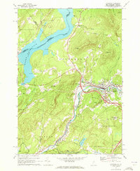 1971 Littleton1973 Print · USGSLittleton and the Ammonoosuc River valley appear here in the early 1970s as modern interstates began to intersect with older rail and river economies. Researchers can trace family sites at North Littleton Cemetery or follow the Boston and Maine line through Barrett.3 unique versions available
 - 1973 Map of Groton, 1975 Print
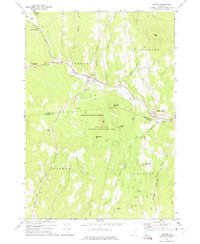 1973 Groton1975 Print · USGSThe Wells River valley in the early 1970s reveals a landscape of upland forests and small mountain settlements. Researchers can trace the Old Railroad Grade past Ricker Mills or locate local burials at Hillside Cem and Pinehurst Cem.
 - 1973 Map of Woodsville, 1976 Print
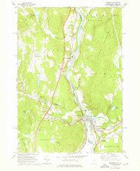 1973 Woodsville1976 Print · USGSThe river-and-rail hub of Woodsville and Wells River is captured here in the early 1970s, where Vermont and New Hampshire meet. Genealogists can locate numerous burial sites including St Josephs Cem and Mills Mem Cem, or trace the path of the Boston and Maine through town.3 unique versions available
End of results
Showing maps 1-3 of 3
Top cities of Caledonia County
- Saint Johnsbury historical maps
- Hardwick historical maps
- Danville historical maps
- Lyndon historical maps
- Sutton historical maps
- Groton historical maps
See more
Frequently asked questions
- What are the different types of historical maps available for Caledonia County?
- What is the oldest map of Caledonia County?
- Where can I purchase historical maps of Caledonia County for my home or office?
- Where can I download high-res historical maps of Caledonia County?
- Are there historical topographic maps available for Caledonia County?
- Is there historical aerial imagery available for Caledonia County?
- Where are historical maps of Caledonia County sourced from?