1940s Maps of Caledonia County, Vermont
Explore 7 historic maps of Caledonia County from the 1940s. These maps offer a rare glimpse into what life looked like during the 1940s — showing old roads, neighborhoods, homes, and landmarks that have changed or disappeared over time.
Whether you're researching your family's past, planning a metal detecting trip, or studying how Caledonia County's landscape evolved across the 1940s, these high-resolution maps are a powerful tool for exploring the history of this region.
- Focus on a specific era: All maps on this page are from the 1940s, giving you a focused view of this time period.
- See what’s changed: Compare century-old streets, trails, and buildings to today's modern landscape using overlays and satellite layers.
- Research with precision: Use these maps for genealogy, historical research, land use analysis, or educational projects.
- View, download, or print: Maps are fully viewable online in high resolution, and can be downloaded or printed for your own records.
Start exploring Caledonia County's history through authentic maps from the 1940s. This is your window into the past.
Caledonia County, VT maps
(7)- 1940 Map of Plainfield, 1953 Print
 1940 Plainfield1953 Print · USGSVermont's hill country is captured here just before the war, showing a landscape defined by small farms and upland schools. Genealogists can locate family landmarks at Maple Cors Calais PO, Old West Ch, and the St Johnsbury and Lake Champlain RR.2 unique versions available
 - 1941 Map of Woodsville
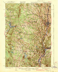
 1941 Woodsville1941 Print · USGSThe Connecticut River valley was a bustling corridor of granite quarries and rail junctions just before the war. You can trace the legacy of local industry and education through landmarks like Gibson Quarry, the County Poor Farm, and Town Farm Sch.4 unique versions available
 - 1943 Map of Plainfield
 1943 Plainfield1943 Print · USGSVermont's highland farming and rail communities are captured here in the 1940s as the state's rural landscape remained densely settled. Genealogists can locate family-named landmarks like Hollister Hill Sch, trace the Montpelier and Wells River RR, or find the Old West Ch near Kent Cors.2 unique versions available
 - 1943 Map of St. Johnsbury
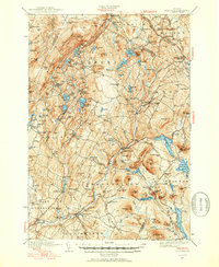
 1943 St. Johnsbury1943 Print · USGSUpper Vermont and New Hampshire communities thrive along the Connecticut and Passumpsic rivers during the early war years. Genealogists can trace family names at Walden Four Corners, find rural schoolhouses like Stanton Sch, or locate the Goslants Mill site.3 unique versions available
 - 1947 Map of Corinth
 1947 Corinth1947 Print · USGSThe granite quarrying region of Vermont is captured here just after the war, showing the industrial density of the hills. Genealogists can trace family roots through numerous local landmarks like Wilson Cem, Miles Sch, and settlements such as Goose Green and Websterville.
 - 1948 Map of East Barre
 1948 East Barre1948 Print · USGSCentral Vermont's quarrying and timber lands are captured here just after the war, showing the industrial centers of the Knox Mountains area. Genealogists can trace family roots through numerous remote burial grounds like Hutchinson Cem and schoolhouses such as Quarry Sch.2 unique versions available
 - 1949 Map of St. Johnsbury, 1957 Print
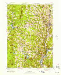 1949 St. Johnsbury1957 Print · USGSCaledonia County and the upper Connecticut River valley are captured here just after the war, showing a landscape defined by rail and river. Genealogists and local historians can locate early landmarks like Walden Four Corners, the Frank D Comerford Hydro-electric Plant, and the historic Hazen Road.3 unique versions available
End of results
Showing maps 1-7 of 7
Top cities of Caledonia County
- Saint Johnsbury historical maps
- Hardwick historical maps
- Danville historical maps
- Lyndon historical maps
- Sutton historical maps
- Groton historical maps
See more
Frequently asked questions
- What are the different types of historical maps available for Caledonia County?
- What is the oldest map of Caledonia County?
- Where can I purchase historical maps of Caledonia County for my home or office?
- Where can I download high-res historical maps of Caledonia County?
- Are there historical topographic maps available for Caledonia County?
- Is there historical aerial imagery available for Caledonia County?
- Where are historical maps of Caledonia County sourced from?