
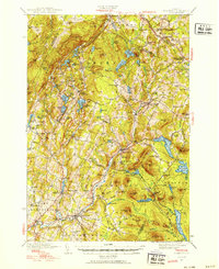
1940 Map of Plainfield
USGS Topo · Published 1953About this map
Woodbury Mountain and the high ridges of the Woodbury range dominate this 1940s landscape, where a dense network of hill-country schools and cemeteries reflects a settled agricultural era. The village of Plainfield sits along the Winooski River, while the St Johnsbury and Lake Champlain RR cuts across the northern reaches near Walden Heights Walden Sta. This period finds the region transitioning its water resources, evidenced by the presence of the Mollys Falls Reservoir and the Power House near Marshfield. Local centers like Maple Cors Calais PO and South Woodbury are captured before modern infrastructure altered the rural character of these crossroads. Numerous small water bodies such as Shadow Lake and Nichols Pond are interspersed between family-named landmarks like Hollister Hill and Burbank Hill, providing a detailed look at land ownership and community structure prior to mid-century shifts.
Find a feature on this map
151 named features on this map. Tap any name to fly to it.
Don’t see what you’re looking for? This feature index may not catch every label — zoom into the map to look around manually.
Map Details
Editions of this 1940 Plainfield Map
2 editions found
Other maps of this area

1919 · Montpelier
USGS Topo · 1:62,500

1921 · Montpelier
USGS Topo · 1:62,500

1922 · Barre
USGS Topo · 1:48,000

1924 · Barre
USGS Topo · 1:62,500

1927 · Hyde Park
USGS Topo · 1:48,000

1928 · Hardwick
USGS Topo · 1:62,500

1930 · Hyde Park
USGS Topo · 1:62,500

1931 · Woodsville
USGS Topo · 1:48,000

1934 · Hardwick
USGS Topo · 1:48,000

1935 · Woodsville
USGS Topo · 1:62,500