
1948 Map of East Barre
USGS Topo · Published 1948About this map
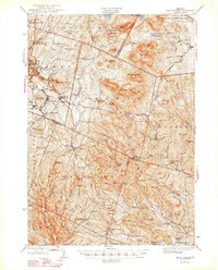
Waites River and its various branches carve through this high-altitude landscape of central Vermont, where the granite industry shaped the communities of Websterville, Lower Websterville, and Graniteville. The map depicts a rugged terrain dominated by the Knox Mountains and peaks like Signal Mtn and Butterfield Mtn, dotted with numerous rural district schools such as Miles Sch and Simpson Sch. Public lands are prominently featured, including Jones State Forest and Groton State Forest, the latter of which features a Fire Tower atop Spruce Mtn. The infrastructure of the era is evident in the E Barre Dam and the Memorial Highway, while numerous family-named landmarks like Colby Hill and Lyme Ember Hill provide valuable points of reference for genealogists. The transition from industrial quarrying towns to remote forested ridges highlights the unique geographic character of Orange and Washington counties in the post-war years.
Find a feature on this map
107 named features on this map. Tap any name to fly to it.
Don’t see what you’re looking for? This feature index may not catch every label — zoom into the map to look around manually.
Map Details
Editions of this 1948 East Barre Map
2 editions found
Other maps of this area

1896 · Strafford
USGS Topo · 1:62,500

1919 · Royalton
USGS Topo · 1:62,500

1919 · Montpelier
USGS Topo · 1:62,500

1921 · Montpelier
USGS Topo · 1:62,500

1922 · Barre
USGS Topo · 1:48,000

1924 · Barre
USGS Topo · 1:62,500

1924 · Randolph
USGS Topo · 1:48,000

1926 · Randolph
USGS Topo · 1:62,500

1931 · Mt. Cube
USGS Topo · 1:62,500

1931 · Woodsville
USGS Topo · 1:48,000