1960s Maps of Middletown Springs, Vermont
Explore 5 historic maps of Middletown Springs from the 1960s. These maps offer a rare glimpse into what life looked like during the 1960s — showing old roads, neighborhoods, homes, and landmarks that have changed or disappeared over time.
Whether you're researching your family's past, planning a metal detecting trip, or studying how Middletown Springs's landscape evolved across the 1960s, these high-resolution maps are a powerful tool for exploring the history of this region.
- Focus on a specific era: All maps on this page are from the 1960s, giving you a focused view of this time period.
- See what’s changed: Compare century-old streets, trails, and buildings to today's modern landscape using overlays and satellite layers.
- Research with precision: Use these maps for genealogy, historical research, land use analysis, or educational projects.
- View, download, or print: Maps are fully viewable online in high resolution, and can be downloaded or printed for your own records.
Start exploring Middletown Springs's history through authentic maps from the 1960s. This is your window into the past.
Middletown Springs, VT maps
(5)- 1964 Map of Glens Falls
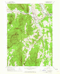
 1964 Glens Falls1964 Print · USGSThe tri-state borderlands of New York, Vermont, and New Hampshire appear here in the mid-1960s. Researchers can trace the rail routes of the Rutland RR and find historic sites like Ticonderoga and Saratoga National Historical Park.
 - 1964 Map of West Rutland, 1965 Print
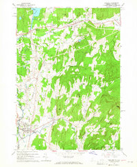
 1964 West Rutland1965 Print · USGSRutland County's industrial and rural character is preserved here in the mid-1960s. Genealogists and historians can trace the rail lines of the Delaware and Hudson Railroad and find long-established sites like Clarendon Springs and Edmunds Cem.4 unique versions available
 - 1964 Map of Poultney, 1965 Print
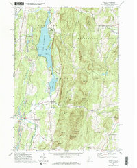
 1964 Poultney1965 Print · USGSRutland County in the mid-1960s shows a landscape shaped by the slate industry and deep-rooted collegiate towns. Researchers can trace historic family cemeteries like Ward Cem and Gates Cem or follow the path of the Delaware and Hudson railroad.4 unique versions available
 - 1967 Map of Wells, 1972 Print
 1967 Wells1972 Print · USGSThe Vermont-New York borderlands near Wells were characterized by a mix of summer recreation and mountain industry in the 1960s. Researchers can trace the slate-country heritage through various Quarries or locate family sites at Barden Cem and Blossom Corners.2 unique versions available
 - 1967 Map of Middletown Springs, 1972 Print
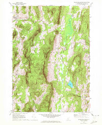 1967 Middletown Springs1972 Print · USGSMiddletown Springs and the surrounding Taconic foothills appear here during the late 1960s, a period of transition for these rural Vermont communities. Genealogists and local historians can locate family plots at Tinmouth Cem or Staples Cem and trace old homesteads near Chipman Lake.3 unique versions available
End of results
Showing maps 1-5 of 5
Top cities near Middletown Springs
- Rutland City historical maps
- Granville historical maps
- Whitehall historical maps
- Poultney historical maps
- Poultney Village historical maps
- Fair Haven historical maps
See more
Top neighborhoods of Middletown Springs
Frequently asked questions
- What are the different types of historical maps available for Middletown Springs?
- What is the oldest map of Middletown Springs?
- Where can I purchase historical maps of Middletown Springs for my home or office?
- Where can I download high-res historical maps of Middletown Springs?
- Are there historical topographic maps available for Middletown Springs?
- Is there historical aerial imagery available for Middletown Springs?
- Where are historical maps of Middletown Springs sourced from?