1970s Maps of Mount Holly, Vermont
Explore 1 historic maps of Mount Holly from the 1970s. These maps offer a rare glimpse into what life looked like during the 1970s — showing old roads, neighborhoods, homes, and landmarks that have changed or disappeared over time.
Whether you're researching your family's past, planning a metal detecting trip, or studying how Mount Holly's landscape evolved across the 1970s, these high-resolution maps are a powerful tool for exploring the history of this region.
- Focus on a specific era: All maps on this page are from the 1970s, giving you a focused view of this time period.
- See what’s changed: Compare century-old streets, trails, and buildings to today's modern landscape using overlays and satellite layers.
- Research with precision: Use these maps for genealogy, historical research, land use analysis, or educational projects.
- View, download, or print: Maps are fully viewable online in high resolution, and can be downloaded or printed for your own records.
Start exploring Mount Holly's history through authentic maps from the 1970s. This is your window into the past.
Mount Holly, VT maps
(1)- 1971 Map of Ludlow, 1975 Print
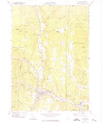 1971 Ludlow1975 Print · USGSVermont's Green Mountain region is captured here in the early 1970s, focused on the riverside communities and high-altitude forests of Windsor County. Local historians can trace the development of Ludlow and Proctorsville, find family plots at Pleasant View Cem, or locate landmarks like Sawyer Rocks and Colby Pond.2 unique versions available
End of results
Showing maps 1-1 of 1
Top cities near Mount Holly
- Rutland City historical maps
- Woodstock historical maps
- Clarendon historical maps
- Ludlow historical maps
- Ludlow Village historical maps
- Manchester historical maps
See more
Top neighborhoods of Mount Holly
- Bowlsville historical maps
- Healdville historical maps
- Mount Holly Heights historical maps
- Tarbellville historical maps
- Hortonville historical maps
- Belmont historical maps
Frequently asked questions
- What are the different types of historical maps available for Mount Holly?
- What is the oldest map of Mount Holly?
- Where can I purchase historical maps of Mount Holly for my home or office?
- Where can I download high-res historical maps of Mount Holly?
- Are there historical topographic maps available for Mount Holly?
- Is there historical aerial imagery available for Mount Holly?
- Where are historical maps of Mount Holly sourced from?