1930s Maps of Guilford, Vermont
Explore 4 historic maps of Guilford from the 1930s. These maps offer a rare glimpse into what life looked like during the 1930s — showing old roads, neighborhoods, homes, and landmarks that have changed or disappeared over time.
Whether you're researching your family's past, planning a metal detecting trip, or studying how Guilford's landscape evolved across the 1930s, these high-resolution maps are a powerful tool for exploring the history of this region.
- Focus on a specific era: All maps on this page are from the 1930s, giving you a focused view of this time period.
- See what’s changed: Compare century-old streets, trails, and buildings to today's modern landscape using overlays and satellite layers.
- Research with precision: Use these maps for genealogy, historical research, land use analysis, or educational projects.
- View, download, or print: Maps are fully viewable online in high resolution, and can be downloaded or printed for your own records.
Start exploring Guilford's history through authentic maps from the 1930s. This is your window into the past.
Guilford, VT maps
(4)- 1932 Map of Brattleboro
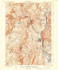
 1932 Brattleboro1932 Print · USGSThe Connecticut River valley comes into sharp focus during the 1930s, showing a landscape of river-side rail and high ridge-lines. Genealogists and historians can trace the Boston and Maine line past West Chesterfield, the Monument Sch, and the notable Childs Monument.
 - 1935 Map of Brattleboro
 1935 Brattleboro1935 Print · USGSThe Connecticut River valley in the mid-1930s reveals a landscape of industrial river towns and upland farming hamlets. Genealogists can trace family sites near Guilford Center or follow the rail stops at Dummerston Station and Putney Station.5 unique versions available
 - 1936 Map of Bernardston
 1936 Bernardston1936 Print · USGSFranklin County and the Vermont border are captured in the mid-1930s when the region was a network of rural school districts and rail-side villages. Genealogists and historians can trace the locations of the The Old Cemetery or specific local schools like West Gill Sch and School No 7.
 - 1937 Map of Colrain
 1937 Colrain1937 Print · USGSNorthwestern Massachusetts hill towns show their industrial and defensive roots in the years before the war. Trace colonial history at the Site of Fort Morrison or locate family homesteads near Griswoldville, Adamsville, and Aunt Sophies Peak.
End of results
Showing maps 1-4 of 4
Top cities near Guilford
- Greenfield historical maps
- Montague historical maps
- Brattleboro historical maps
- Deerfield historical maps
- Winchester historical maps
- Chesterfield historical maps
See more
Top neighborhoods of Guilford
- West Guilford historical maps
- Guilford Center historical maps
- Packer Corner historical maps
- Green River historical maps
Frequently asked questions
- What are the different types of historical maps available for Guilford?
- What is the oldest map of Guilford?
- Where can I purchase historical maps of Guilford for my home or office?
- Where can I download high-res historical maps of Guilford?
- Are there historical topographic maps available for Guilford?
- Is there historical aerial imagery available for Guilford?
- Where are historical maps of Guilford sourced from?