1990s Maps of Westminster, Vermont
Explore 3 historic maps of Westminster from the 1990s. These maps offer a rare glimpse into what life looked like during the 1990s — showing old roads, neighborhoods, homes, and landmarks that have changed or disappeared over time.
Whether you're researching your family's past, planning a metal detecting trip, or studying how Westminster's landscape evolved across the 1990s, these high-resolution maps are a powerful tool for exploring the history of this region.
- Focus on a specific era: All maps on this page are from the 1990s, giving you a focused view of this time period.
- See what’s changed: Compare century-old streets, trails, and buildings to today's modern landscape using overlays and satellite layers.
- Research with precision: Use these maps for genealogy, historical research, land use analysis, or educational projects.
- View, download, or print: Maps are fully viewable online in high resolution, and can be downloaded or printed for your own records.
Start exploring Westminster's history through authentic maps from the 1990s. This is your window into the past.
Westminster, VT maps
(3)- 1997 Map of Westminster West, 2001 Print
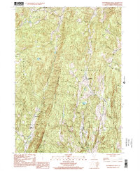 1997 Westminster West2001 Print · USGSWindham County's ridgelines and rural settlements appear here as they were in the late 1990s, before modern development. Genealogists and historians can trace the local landscape through landmarks like the Town Hall (Round School), Union Sch, and the high points of Windmill Mountain.
 - 1998 Map of Walpole, 2002 Print
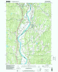 1998 Walpole2002 Print · USGSThe Connecticut River valley at the close of the twentieth century shows a mature landscape of hill-country farming and river-town industry. Genealogists and local researchers can trace family landmarks like Dodge Tavern or explore the grounds of the Kurn Hattin Sch and St Peters Cem.
 - 1998 Map of Bellows Falls, 2002 Print
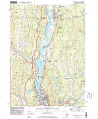 1998 Bellows Falls2002 Print · USGSThe borderlands of Vermont and New Hampshire come alive in the 1990s as the river economy transitions toward modern infrastructure. Trace family names and landmarks from Bellows Falls to Charlestown, finding sites like Bates Mill Pond and the Mt Kilburn Tower.
End of results
Showing maps 1-3 of 3
Top cities near Westminster
- Keene historical maps
- Brattleboro historical maps
- Swanzey historical maps
- Brockways Mills historical maps
- Springfield historical maps
- Winchester historical maps
See more
Top neighborhoods of Westminster
- Westminster Village historical maps
- Westminster West historical maps
- North Westminster historical maps
Frequently asked questions
- What are the different types of historical maps available for Westminster?
- What is the oldest map of Westminster?
- Where can I purchase historical maps of Westminster for my home or office?
- Where can I download high-res historical maps of Westminster?
- Are there historical topographic maps available for Westminster?
- Is there historical aerial imagery available for Westminster?
- Where are historical maps of Westminster sourced from?