1980s Maps of Westminster, Vermont
Explore 5 historic maps of Westminster from the 1980s. These maps offer a rare glimpse into what life looked like during the 1980s — showing old roads, neighborhoods, homes, and landmarks that have changed or disappeared over time.
Whether you're researching your family's past, planning a metal detecting trip, or studying how Westminster's landscape evolved across the 1980s, these high-resolution maps are a powerful tool for exploring the history of this region.
- Focus on a specific era: All maps on this page are from the 1980s, giving you a focused view of this time period.
- See what’s changed: Compare century-old streets, trails, and buildings to today's modern landscape using overlays and satellite layers.
- Research with precision: Use these maps for genealogy, historical research, land use analysis, or educational projects.
- View, download, or print: Maps are fully viewable online in high resolution, and can be downloaded or printed for your own records.
Start exploring Westminster's history through authentic maps from the 1980s. This is your window into the past.
Westminster, VT maps
(5)- 1984 Map of Saxtons River
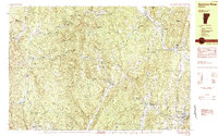 1984 Saxtons River1984 Print · USGSSoutheast Vermont in the 1980s was a landscape of deep river valleys and small villages tucked between the hills. Researchers can trace historic family burial sites at Middletown Cem, follow old roads through Lawrence Four Corners, and locate former mills at Brockways Mills.2 unique versions available
 - 1984 Map of Townshend
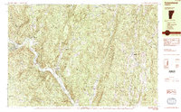 1984 Townshend1984 Print · USGSWindham County life in the mid-1980s is centered on the river valley and the wooded heights of the Green Mountains. Researchers can locate civic landmarks like the Town Hall (Round School) or trace family roots at Riverside Cem and Wiswall Cem.2 unique versions available
 - 1985 Map of Walpole
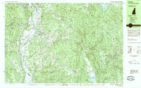 1985 Walpole1985 Print · USGSThe Connecticut River valley in the mid-1980s shows a landscape of upland villages and riverside rail connections along the Vermont and New Hampshire border. Genealogists and historians can trace family-named landmarks like Dodge Tavern, Kingsbury Hill, and St Peters Cem.2 unique versions available
 - 1985 Map of Bellows Falls
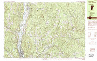 1985 Bellows Falls1985 Print · USGSThe Connecticut River valley comes alive in the mid-eighties as it passes through the industrial hubs and riverside meadows of the Vermont-New Hampshire border. Trace the rail lines of the Boston and Maine or locate family landmarks near Pine Grove Cem and South Acworth.2 unique versions available
 - 1985 Map of Claremont, 1986 Print
 1985 Claremont1986 Print · USGSUpper Valley and Green Mountain life are captured here in the mid-eighties, centered on the river-linked hubs of Claremont and Springfield. Trace old family routes and rail lines like the Boston & Maine RR, or locate properties near Lake Sunapee and Mount Ascutney State Park.2 unique versions available
End of results
Showing maps 1-5 of 5
Top cities near Westminster
- Keene historical maps
- Brattleboro historical maps
- Swanzey historical maps
- Brockways Mills historical maps
- Springfield historical maps
- Winchester historical maps
See more
Top neighborhoods of Westminster
- Westminster Village historical maps
- Westminster West historical maps
- North Westminster historical maps
Frequently asked questions
- What are the different types of historical maps available for Westminster?
- What is the oldest map of Westminster?
- Where can I purchase historical maps of Westminster for my home or office?
- Where can I download high-res historical maps of Westminster?
- Are there historical topographic maps available for Westminster?
- Is there historical aerial imagery available for Westminster?
- Where are historical maps of Westminster sourced from?