1940s Maps of Keller, Virginia
Explore 4 historic maps of Keller from the 1940s. These maps offer a rare glimpse into what life looked like during the 1940s — showing old roads, neighborhoods, homes, and landmarks that have changed or disappeared over time.
Whether you're researching your family's past, planning a metal detecting trip, or studying how Keller's landscape evolved across the 1940s, these high-resolution maps are a powerful tool for exploring the history of this region.
- Focus on a specific era: All maps on this page are from the 1940s, giving you a focused view of this time period.
- See what’s changed: Compare century-old streets, trails, and buildings to today's modern landscape using overlays and satellite layers.
- Research with precision: Use these maps for genealogy, historical research, land use analysis, or educational projects.
- View, download, or print: Maps are fully viewable online in high resolution, and can be downloaded or printed for your own records.
Start exploring Keller's history through authentic maps from the 1940s. This is your window into the past.
Keller, VA maps
(4)- 1943 Map of Pungoteague
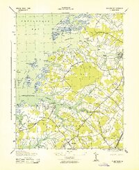 1943 Pungoteague1943 Print · USGSThe Eastern Shore of Virginia in the 1940s reveals a world of maritime necks and historic creek-side settlements. Genealogists and historians can trace family roots through Wards Church, Dinglers Mill, and wartime additions like Virginia Flight Strip No 1.2 unique versions available
 - 1943 Map of Exmore, 1962 Print
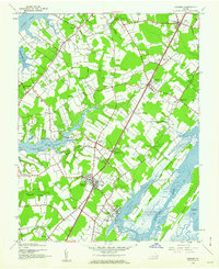 1943 Exmore1962 Print · USGSThe Virginia Eastern Shore is captured here during the 1940s, showing a landscape defined by the PENNSYLVANIA railroad and tidal creeks. Researchers can locate family landmarks like Willis Wharf, Savage Town, and numerous schools including Painter H S.
 - 1944 Map of Exmore
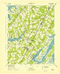 1944 Exmore1944 Print · USGSCoastal Virginia during the Second World War reveals a landscape of tidal creeks and rail-side hamlets. Researchers can trace the maritime economy through Cedar View Wharf and the Pennsylvania railroad line connecting Exmore and Painter.
 - 1946 Map of Eastville, 1971 Print
 1946 Eastville1971 Print · USGSCoastal Virginia and the Outer Banks are captured here during a period of expanding naval and aerospace presence. Researchers can trace the path of the Penn Central railroad through Chincoteague and Modest Town, or locate landmarks like the Wright Brothers National Memorial.
End of results
Showing maps 1-4 of 4
Top cities near Keller
- Exmore historical maps
- Onancock historical maps
- Parksley historical maps
- Pastoria historical maps
- Nassawadox historical maps
- Accomac historical maps
See more
Frequently asked questions
- What are the different types of historical maps available for Keller?
- What is the oldest map of Keller?
- Where can I purchase historical maps of Keller for my home or office?
- Where can I download high-res historical maps of Keller?
- Are there historical topographic maps available for Keller?
- Is there historical aerial imagery available for Keller?
- Where are historical maps of Keller sourced from?