Old Maps of Southwood Estates Mobile Home Park, Albemarle County for Genealogy
Trace your family roots with 13 historic maps of Southwood Estates Mobile Home Park. These high-res maps reveal old neighborhoods, homesites, landmarks, and streets — helping you uncover where your ancestors lived and how the area evolved over time.
- Explore historic neighborhoods: Identify where your relatives may have lived in the 1800s or 1900s.
- Compare maps over time: Trace the changes in streets, buildings, and landmarks for multi-generational research.
- Perfect for genealogy & ancestry research: Used by family historians and researchers to map out lineage and migration.
These maps are an incredible resource for exploring your personal connection to Southwood Estates Mobile Home Park's past.
Southwood Estates Mobile Home Park, Albemarle County maps
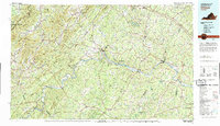
(13)- 1892 Map of Buckingham
 1892 Buckingham1892 Print · USGSCovers Southwood Estates Mobile Home Park, including Nellysford, Arrington, and other nearby areas7 unique versions available
 - 1929 Map of Covesville
 1929 Covesville1929 Print · USGSCovers Southwood Estates Mobile Home Park, including Scottsville, North Garden, and other nearby areas3 unique versions available
 - 1935 Map of Charlottesville And Vicinity
 1935 Charlottesville And Vicinity1935 Print · USGSCovers Southwood Estates Mobile Home Park, including Charlottesville, University of Virginia, and other nearby areas
 - 1935 Map of Covesville, 1961 Print
 1935 Covesville1961 Print · USGSCovers Southwood Estates Mobile Home Park, including Scottsville, North Garden, and other nearby areas
 - 1945 Map of Covesville
 1945 Covesville1945 Print · USGSCovers Southwood Estates Mobile Home Park, including Scottsville, North Garden, and other nearby areas
 - 1947 Map of Roanoke, 1948 Print
 1947 Roanoke1948 Print · USGSCovers Southwood Estates Mobile Home Park, including Roanoke, Lynchburg, and other nearby areas2 unique versions available
 - 1959 Map of Roanoke
 1959 Roanoke1959 Print · USGSCovers Southwood Estates Mobile Home Park, including Roanoke, Lynchburg, and other nearby areas
 - 1960 Map of Charlottesville And Vicinity
 1960 Charlottesville And Vicinity1960 Print · USGSCovers Southwood Estates Mobile Home Park, including Charlottesville, University of Virginia, and other nearby areas
 - 1963 Map of Roanoke
 1963 Roanoke1963 Print · USGSCovers Southwood Estates Mobile Home Park, including Roanoke, Lynchburg, and other nearby areas
 - 1967 Map of Alberene, 1968 Print
 1967 Alberene1968 Print · USGSCovers Southwood Estates Mobile Home Park, including Arrowhead, Powell Corner, and other nearby areas2 unique versions available
 - 1971 Map of Roanoke, 1977 Print
 1971 Roanoke1977 Print · USGSCovers Southwood Estates Mobile Home Park, including Roanoke, Lynchburg, and other nearby areas2 unique versions available
 - 1979 Map of Dillwyn, 1982 Print
 1979 Dillwyn1982 Print · USGSCovers Southwood Estates Mobile Home Park, including Lake Monticello, Rivanna, and other nearby areas
 - 1979 Map of Alberene, 1982 Print
 1979 Alberene1982 Print · USGSCovers Southwood Estates Mobile Home Park, including Arrowhead, Powell Corner, and other nearby areas
End of results
Showing maps 1-13 of 13
Frequently asked questions
- What are the different types of historical maps available for Southwood Estates Mobile Home Park?
- What is the oldest map of Southwood Estates Mobile Home Park?
- Where can I purchase historical maps of Southwood Estates Mobile Home Park for my home or office?
- Where can I download high-res historical maps of Southwood Estates Mobile Home Park?
- Are there historical topographic maps available for Southwood Estates Mobile Home Park?
- Is there historical aerial imagery available for Southwood Estates Mobile Home Park?
- Where are historical maps of Southwood Estates Mobile Home Park sourced from?