1950s Maps of Campbell County, Virginia
Explore 7 historic maps of Campbell County from the 1950s. These maps offer a rare glimpse into what life looked like during the 1950s — showing old roads, neighborhoods, homes, and landmarks that have changed or disappeared over time.
Whether you're researching your family's past, planning a metal detecting trip, or studying how Campbell County's landscape evolved across the 1950s, these high-resolution maps are a powerful tool for exploring the history of this region.
- Focus on a specific era: All maps on this page are from the 1950s, giving you a focused view of this time period.
- See what’s changed: Compare century-old streets, trails, and buildings to today's modern landscape using overlays and satellite layers.
- Research with precision: Use these maps for genealogy, historical research, land use analysis, or educational projects.
- View, download, or print: Maps are fully viewable online in high resolution, and can be downloaded or printed for your own records.
Start exploring Campbell County's history through authentic maps from the 1950s. This is your window into the past.
Campbell County, VA maps
(7)- 1950 Map of Goode, 1952 Print
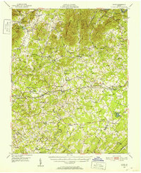 1950 Goode1952 Print · USGSMid-century Bedford and Campbell Counties are documented here as the rural landscape meets the mountains. Genealogists can trace the location of numerous country landmarks like Poplar Forest, Coltons Mill, and the many schools and churches including North Bedford Ch.3 unique versions available
 - 1950 Map of Lynchburg, 1963 Print
 1950 Lynchburg1963 Print · USGSMid-century Lynchburg and the surrounding Piedmont hills are caught in a moment of industrial and rail prominence. Researchers can trace the legacy of local commerce and community through landmarks like Oxford Furnace, Tomahawk Mill, and Lynchburg Womens College.
 - 1951 Map of Altavista, 1953 Print
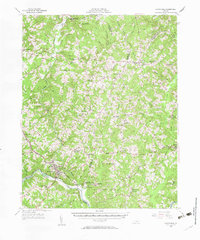
 1951 Altavista1953 Print · USGSThe Roanoke River valley in the early fifties shows a region defined by its rail-and-river economy and tight-knit rural communities. Genealogists and local historians can trace family roots through landmarks like Bethlehem Ch, Lynch Sta, and Greasy Sch.2 unique versions available
 - 1956 Map of Brookneal, 1957 Print
 1956 Brookneal1957 Print · USGSBrookneal and the southern Piedmont are seen here in the mid-1950s at the confluence of the Staunton and Falling rivers. Genealogists and historians can locate family landmarks such as Red Hill (Home of Patrick Henry), Hat Creek Sch, and the St Lukes Ch.2 unique versions available
 - 1956 Map of Gladys, 1957 Print
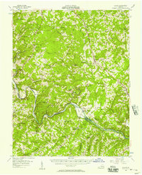 1956 Gladys1957 Print · USGSSouthern Campbell County in the mid-fifties is captured here as a landscape of rail-junction towns and river-bottom farms. Genealogists can trace family roots through numerous local landmarks like Mitchell Mill, Organ Chapel, and the Franklin Cem.2 unique versions available
 - 1958 Map of Appomattox, 1960 Print
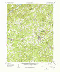 1958 Appomattox1960 Print · USGSCentral Virginia is captured in the late fifties as the rail-side towns of Appomattox and Concord thrive. Genealogists can trace family landmarks like Earlys Chapel Cem and historic sites such as the McLean House.2 unique versions available
 - 1959 Map of Roanoke
 1959 Roanoke1959 Print · USGSCentral Virginia and the Blue Ridge appear in great detail during the late fifties, showcasing the transition from mountain industry to Piedmont farmland. Trace the path of the Norfolk and Western railroad or find old river towns like Appomattox and Amelia Court House.
End of results
Showing maps 1-7 of 7
Top cities of Campbell County
- Timberlake historical maps
- Altavista historical maps
- Concord historical maps
- Rustburg historical maps
- Brookneal historical maps
Frequently asked questions
- What are the different types of historical maps available for Campbell County?
- What is the oldest map of Campbell County?
- Where can I purchase historical maps of Campbell County for my home or office?
- Where can I download high-res historical maps of Campbell County?
- Are there historical topographic maps available for Campbell County?
- Is there historical aerial imagery available for Campbell County?
- Where are historical maps of Campbell County sourced from?