1970s Maps of Chesapeake, Virginia
Explore 5 historic maps of Chesapeake from the 1970s. These maps offer a rare glimpse into what life looked like during the 1970s — showing old roads, neighborhoods, homes, and landmarks that have changed or disappeared over time.
Whether you're researching your family's past, planning a metal detecting trip, or studying how Chesapeake's landscape evolved across the 1970s, these high-resolution maps are a powerful tool for exploring the history of this region.
- Focus on a specific era: All maps on this page are from the 1970s, giving you a focused view of this time period.
- See what’s changed: Compare century-old streets, trails, and buildings to today's modern landscape using overlays and satellite layers.
- Research with precision: Use these maps for genealogy, historical research, land use analysis, or educational projects.
- View, download, or print: Maps are fully viewable online in high resolution, and can be downloaded or printed for your own records.
Start exploring Chesapeake's history through authentic maps from the 1970s. This is your window into the past.
Chesapeake, VA maps
(5)- 1977 Map of Lake Drummond SE, 1978 Print
 1977 Lake Drummond SE1978 Print · USGSThe Virginia and North Carolina borderlands come into focus in the late 1970s, showcasing the intricate drainage of the southern Great Dismal Swamp. Researchers can trace family history through sites like Lake Drummond Ch or locate the Old Railroad Grade and Culpeper Island.
 - 1977 Map of Lake Drummond NW, 1978 Print
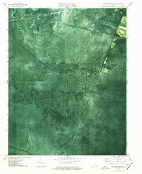 1977 Lake Drummond NW1978 Print · USGSThe Great Dismal Swamp appears in the late seventies as a massive network of historic drainage canals and dense forest. Researchers can trace the geometric paths of Washington Ditch and Jericho Ditch or locate the solitary Lookout Tower standing deep within the refuge.3 unique versions available
 - 1977 Map of Lake Drummond, 1978 Print
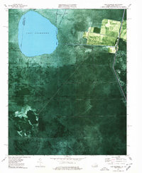 1977 Lake Drummond1978 Print · USGSThe Great Dismal Swamp and Lake Drummond are captured here in the late seventies, showing the complex boundary between Virginia and North Carolina. Genealogists and researchers can trace the old settlements of Wallaceton and Arbuckle Landing along the George Washington Highway.2 unique versions available
 - 1977 Map of Deep Creek, 1978 Print
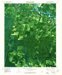 1977 Deep Creek1978 Print · USGSThe Chesapeake area in the late seventies is captured here as suburban growth meets the ancient Great Dismal Swamp. Trace the industrial and social landscape via the Dismal Swamp Canal, St Bethlehem Ch, and the settlement at Great Bridge.2 unique versions available
 - 1977 Map of Creeds, 1979 Print
 1977 Creeds1979 Print · USGSThe Virginia and North Carolina borderlands come to life in this late 1970s aerial survey. Researchers can trace the layout of coastal settlements like Creeds and Munden alongside the marshes of the North Landing River.
End of results
Showing maps 1-5 of 5
Top cities of Chesapeake
Frequently asked questions
- What are the different types of historical maps available for Chesapeake?
- What is the oldest map of Chesapeake?
- Where can I purchase historical maps of Chesapeake for my home or office?
- Where can I download high-res historical maps of Chesapeake?
- Are there historical topographic maps available for Chesapeake?
- Is there historical aerial imagery available for Chesapeake?
- Where are historical maps of Chesapeake sourced from?