1990s Maps of Leader, Virginia
Explore 1 historic maps of Leader from the 1990s. These maps offer a rare glimpse into what life looked like during the 1990s — showing old roads, neighborhoods, homes, and landmarks that have changed or disappeared over time.
Whether you're researching your family's past, planning a metal detecting trip, or studying how Leader's landscape evolved across the 1990s, these high-resolution maps are a powerful tool for exploring the history of this region.
- Focus on a specific era: All maps on this page are from the 1990s, giving you a focused view of this time period.
- See what’s changed: Compare century-old streets, trails, and buildings to today's modern landscape using overlays and satellite layers.
- Research with precision: Use these maps for genealogy, historical research, land use analysis, or educational projects.
- View, download, or print: Maps are fully viewable online in high resolution, and can be downloaded or printed for your own records.
Start exploring Leader's history through authentic maps from the 1990s. This is your window into the past.
Leader, VA maps
(1)- 1994 Map of Beach, 1996 Print
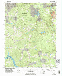 1994 Beach1996 Print · USGSChesterfield and the surrounding forest lands are captured in the mid-1990s as the area maintained its rural character and extensive parklands. Genealogists and hikers can trace family sites like Witson Cem or explore the shores of Lake Chesdin and Lake Margaret.
End of results
Showing maps 1-1 of 1
Top cities near Leader
- Petersburg historical maps
- Chester historical maps
- Meadowbrook historical maps
- Colonial Heights historical maps
- Rockwood historical maps
- Bellwood historical maps
See more
Frequently asked questions
- What are the different types of historical maps available for Leader?
- What is the oldest map of Leader?
- Where can I purchase historical maps of Leader for my home or office?
- Where can I download high-res historical maps of Leader?
- Are there historical topographic maps available for Leader?
- Is there historical aerial imagery available for Leader?
- Where are historical maps of Leader sourced from?