1900s (20th Century) Maps of Winterpock, Virginia
Explore 10 historic maps of Winterpock from the 1900s (20th Century). These maps offer a rare glimpse into what life looked like during the 1900s — showing old roads, neighborhoods, homes, and landmarks that have changed or disappeared over time.
Whether you're researching your family's past, planning a metal detecting trip, or studying how Winterpock's landscape evolved across the 1900s, these high-resolution maps are a powerful tool for exploring the history of this region.
- Focus on a specific era: All maps on this page are from the 1900s, giving you a focused view of this time period.
- See what’s changed: Compare century-old streets, trails, and buildings to today's modern landscape using overlays and satellite layers.
- Research with precision: Use these maps for genealogy, historical research, land use analysis, or educational projects.
- View, download, or print: Maps are fully viewable online in high resolution, and can be downloaded or printed for your own records.
Start exploring Winterpock's history through authentic maps from the 1900s. This is your window into the past.
Winterpock, VA maps
(10)- 1943 Map of Winterpock, 1961 Print
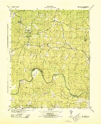
 1943 Winterpock1961 Print · USGSVirginia's rural interior during the 1940s is shown in detail here as the coal-mining community of Winterpock and its surrounding countryside are mapped. Researchers can locate local landmarks like Bethia Ch, the Winterpock School, and the winding Appomattox River.
 - 1943 Map of Richmond, 1972 Print
 1943 Richmond1972 Print · USGSCoastal Virginia and the state capital are shown in detail during the mid-century era of infrastructure expansion. Genealogists and historians can trace the grounds of Richmond Nat Battlefield Park, locate the Yorktown Nat Cem, or follow the many rural routes through Amelia Court House and Tappahannock.
 - 1944 Map of Winterpock
 1944 Winterpock1944 Print · USGSMid-century Chesterfield County is shown here as a rural landscape of creek-fed timberland and quiet crossroads just before the post-war boom. Genealogists can trace family footprints at Winterpock School, Whites Store, and Centenary Church.
 - 1949 Map of Richmond, 1951 Print
 1949 Richmond1951 Print · USGSCoastal Virginia in the years following World War II remained a landscape of historic river towns and expanding military bases. Genealogists and historians can trace the rail lines of the Southern Ry and locate established landmarks from Camp Lee to the remote reaches of Dragon Swamp.
 - 1959 Map of Richmond
 1959 Richmond1959 Print · USGSMid-century Virginia is captured here at its most vital rail and river junctions, from the capital city to the Chesapeake Bay. Genealogists and historians can trace the development of colonial settlements like Williamsburg and military landmarks including Fort Monroe and Camp Lee.
 - 1963 Map of Winterpock, 1965 Print
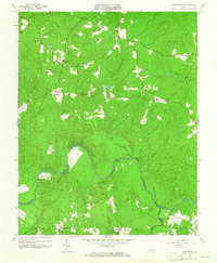 1963 Winterpock1965 Print · USGSChesterfield and Amelia counties are divided by the winding Appomattox River in this mid-century survey. Genealogists can trace family connections through local landmarks like Winterpock School, the Second Branch Church and Cemetery, and Whites Store.4 unique versions available
 - 1964 Map of Richmond
 1964 Richmond1964 Print · USGSCoastal and central Virginia are mapped during the mid-twentieth century, showing the critical intersection of rail, river, and military life. Genealogists can trace family roots through rural county seats like Amelia or find vanished coastal neighborhoods near Phoebus and Hilton Village.
 - 1973 Map of Richmond, 1974 Print
 1973 Richmond1974 Print · USGSThe Virginia Tidewater and Piedmont come alive in the early seventies, showcasing a region defined by its great rivers and massive military installations. Researchers can trace the mid-century growth of Richmond or locate family sites near Amelia Court House and Highland Springs.2 unique versions available
 - 1979 Map of Winterpock, 1982 Print
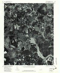 1979 Winterpock1982 Print · USGSSouthern Chesterfield County is captured in the late seventies just as the landscape around the Appomattox River was maturing. Local historians can trace rural property lines and woodlots near the Winterpock settlement and along the shores of Lake Chesdin.
 - 1984 Map of Petersburg, 1985 Print
 1984 Petersburg1985 Print · USGSCentral Virginia in the mid-eighties shows a complex landscape of growing suburban centers and significant military installations. Researchers can trace historic boundaries and civic sites from Amelia Court House to the Glendale Nat Cem and Virginia State College.2 unique versions available
End of results
Showing maps 1-10 of 10
Top cities near Winterpock
- Bon Air historical maps
- Manchester historical maps
- Rockwood historical maps
- Woodlake historical maps
- Chesterfield historical maps
- Powhatan historical maps
Frequently asked questions
- What are the different types of historical maps available for Winterpock?
- What is the oldest map of Winterpock?
- Where can I purchase historical maps of Winterpock for my home or office?
- Where can I download high-res historical maps of Winterpock?
- Are there historical topographic maps available for Winterpock?
- Is there historical aerial imagery available for Winterpock?
- Where are historical maps of Winterpock sourced from?