1900s (20th Century) Maps of Webbtown, Virginia
Explore 15 historic maps of Webbtown from the 1900s (20th Century). These maps offer a rare glimpse into what life looked like during the 1900s — showing old roads, neighborhoods, homes, and landmarks that have changed or disappeared over time.
Whether you're researching your family's past, planning a metal detecting trip, or studying how Webbtown's landscape evolved across the 1900s, these high-resolution maps are a powerful tool for exploring the history of this region.
- Focus on a specific era: All maps on this page are from the 1900s, giving you a focused view of this time period.
- See what’s changed: Compare century-old streets, trails, and buildings to today's modern landscape using overlays and satellite layers.
- Research with precision: Use these maps for genealogy, historical research, land use analysis, or educational projects.
- View, download, or print: Maps are fully viewable online in high resolution, and can be downloaded or printed for your own records.
Start exploring Webbtown's history through authentic maps from the 1900s. This is your window into the past.
Webbtown, VA maps
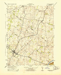
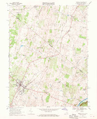
(15)- 1916 Map of Berryville, 1920 Print
 1916 Berryville1920 Print · USGSThe lower Shenandoah Valley at the onset of the Great War was a landscape defined by its river ferries and growing rail lines. Genealogists and historians can trace the foundations of local life through rural landmarks like Mountain Mission, Furnace School, and the river crossing at Shannondale Ferry.2 unique versions available
 - 1939 Map of Berryville
 1939 Berryville1939 Print · USGSNorthern Virginia and the West Virginia borderlands appear here in the late thirties as a landscape of river fords and mountain gaps. Genealogists can trace family names at Locke Mill, Shepherd Ford, and the Mt Olive Cem.
 - 1944 Map of Berryville
 1944 Berryville1944 Print · USGSBerryville and the fertile Clarke County farmlands are captured in the 1940s as the rail lines of the Norfolk and Western and Baltimore and Ohio shaped local trade. Genealogists and historians can trace family locations near Beulah Church, Peagans Mill, and Rippon.
 - 1944 Map of Berryville
 1944 Berryville1944 Print · USGSThe Virginia and West Virginia borderlands are captured here in the mid-1940s, showing the agricultural valley around Berryville meeting the steep Blue Ridge. Researchers can trace the path of the Appalachian Trail or locate vanished landmarks like Boyds Ferry and the Yellow Schoolhouse.
 - 1948 Map of Baltimore
 1948 Baltimore1948 Print · USGSMaryland and Pennsylvania crossroads are captured in the late 1940s, showing a landscape defined by historic rail lines and major military installations. Genealogists can trace family connections in Gettysburg, Westminster, and near the U.S. Naval Academy in Annapolis.2 unique versions available
 - 1953 Map of Berryville
 1953 Berryville1953 Print · USGSBerryville and the surrounding Shenandoah Valley come alive in this mid-century survey, capturing a cross-border community linked by major railroads. Genealogists can trace family connections through markers like Beulah Church, Feagans Mill, and small settlements like Rippon.
 - 1954 Map of Baltimore
 1954 Baltimore1954 Print · USGSThe Mid-Atlantic region in the early fifties shows a landscape of growing suburban centers and heavy rail corridors. Trace mid-century transit networks and military landmarks from the Aberdeen Proving Ground to the Gettysburg National Military Park.
 - 1955 Map of Berryville, 1956 Print
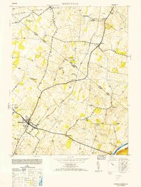
 1955 Berryville1956 Print · USGSThe Shenandoah Valley during the mid-fifties remains an agricultural and spiritual landscape defined by its classic rail-and-river network. Genealogists and historians can trace family roots through Audley Farm, the Cistercian Monastery, and rural hamlets like Wickliffe or Rippon.
 - 1956 Map of Baltimore
 1956 Baltimore1956 Print · USGSMid-century Maryland and Pennsylvania are captured here during a period of massive suburban and military growth across the Chesapeake region. Genealogists and historians can trace the rail corridors of the Baltimore & Ohio RR and locate landmarks like Fort McHenry or the Aberdeen Proving Ground.
 - 1957 Map of Baltimore, 1964 Print
 1957 Baltimore1964 Print · USGSMaryland and Southern Pennsylvania are shown during the mid-century expansion of the Baltimore-Washington corridor. Researchers can trace the extensive rail lines of the Baltimore & Ohio RR and locate sites like Fort Detrick and Gettysburg National Military Park.5 unique versions available
 - 1961 Map of Baltimore
 1961 Baltimore1961 Print · USGSMaryland and Pennsylvania are captured at a mid-century peak of industrial and military expansion. Genealogists and historians can trace rail corridors like the Western Maryland Ry or locate regional landmarks such as Camp Detrick and Kent Island.
 - 1968 Map of Berryville, 1969 Print
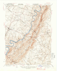
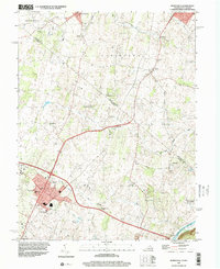
 1968 Berryville1969 Print · USGSBerryville and its surrounding valley were thriving rail and farming hubs in the late sixties as West Virginia and Virginia converged. Genealogists can trace family footprints at Holy Cross Monastery, Prosperity Ch, and local schools like Grafton Sch.4 unique versions available
 - 1984 Map of Frederick, 1985 Print
 1984 Frederick1985 Print · USGSMaryland's Piedmont and the Potomac River valley are shown here in the mid-eighties as suburban growth began to meet historic rural landscapes. Genealogists and historians can trace the paths of the Baltimore and Ohio RR or locate the boundaries of Antietam National Battlefield and Fort Detrick.
 - 1989 Map of Baltimore
 1989 Baltimore1989 Print · USGSThe Mid-Atlantic corridor in the late eighties is captured here, from the Baltimore harbor to the Blue Ridge foothills. Researchers can trace the sprawling footprints of Aberdeen Proving Ground, the historic grounds of Gettysburg National Military Park, and the winding Susquehanna River.
 - 1997 Map of Berryville, 2001 Print
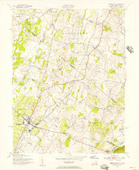
 1997 Berryville2001 Print · USGSThe Virginia and West Virginia state line cuts through the Shenandoah Valley in the late nineties, documenting a landscape of rural hamlets and deep-rooted institutions. Genealogists can trace family names across Green Hill Cemetery, locate the Holy Cross Monastery, and explore small settlements like Rippon and Gaylord.
End of results
Showing maps 1-15 of 15
Top cities near Webbtown
- Winchester historical maps
- Front Royal historical maps
- Purcellville historical maps
- Charles Town historical maps
- Ranson historical maps
- Berryville historical maps
See more
Frequently asked questions
- What are the different types of historical maps available for Webbtown?
- What is the oldest map of Webbtown?
- Where can I purchase historical maps of Webbtown for my home or office?
- Where can I download high-res historical maps of Webbtown?
- Are there historical topographic maps available for Webbtown?
- Is there historical aerial imagery available for Webbtown?
- Where are historical maps of Webbtown sourced from?