1950s Maps of Herndon, Virginia
Explore 5 historic maps of Herndon from the 1950s. These maps offer a rare glimpse into what life looked like during the 1950s — showing old roads, neighborhoods, homes, and landmarks that have changed or disappeared over time.
Whether you're researching your family's past, planning a metal detecting trip, or studying how Herndon's landscape evolved across the 1950s, these high-resolution maps are a powerful tool for exploring the history of this region.
- Focus on a specific era: All maps on this page are from the 1950s, giving you a focused view of this time period.
- See what’s changed: Compare century-old streets, trails, and buildings to today's modern landscape using overlays and satellite layers.
- Research with precision: Use these maps for genealogy, historical research, land use analysis, or educational projects.
- View, download, or print: Maps are fully viewable online in high resolution, and can be downloaded or printed for your own records.
Start exploring Herndon's history through authentic maps from the 1950s. This is your window into the past.
Herndon, VA maps
(5)- 1951 Map of Herndon, 1952 Print
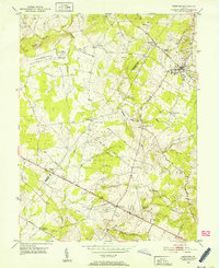 1951 Herndon1952 Print · USGSNorthern Virginia at mid-century remains a landscape of small settlements and emerging federal outposts. Genealogists can trace family names and early community centers like Frying Pan Ch, Chantilly, and the Chestnut Grove Cem along the old rail lines.
 - 1951 Map of Vienna, 1952 Print
 1951 Vienna1952 Print · USGSFairfax County was transitioning from a rural landscape to a suburban hub in the early fifties. Genealogists and historians can trace family-named landmarks and early neighborhoods like Vienna Woods, Clarks Crossing, and Browns Chapel Cem.
 - 1956 Map of Herndon, 1958 Print
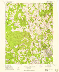
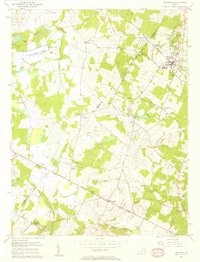 1956 Herndon1958 Print · USGSThe northern Virginia countryside is captured here in the mid-fifties, just before modern suburbanization transformed the region. Researchers can trace historical crossroads and institutional centers such as Floris, Chantilly, and the venerable Frying Pan Ch.2 unique versions available
 - 1957 Map of Vienna, 1958 Print
 1957 Vienna1958 Print · USGSFairfax County was rapidly evolving in the mid-fifties as suburban growth began to surround established rail stops. Genealogists can trace family landmarks and rural roots at Browns Chapel Cem, Clarks Crossing, and along the Washington and Old Dominion Railroad.
 - 1957 Map of Washington, 1966 Print
 1957 Washington1966 Print · USGSThe mid-Atlantic region during the mid-fifties and early sixties reveals a landscape of growing suburbs and vital military outposts. Researchers can trace historic river towns and shorelines from Alexandria to the Hooper Islands and St Clements Island.5 unique versions available
End of results
Showing maps 1-5 of 5
Top cities near Herndon
- Germantown historical maps
- Centreville historical maps
- Gaithersburg historical maps
- Rockville historical maps
- Reston historical maps
- Leesburg historical maps
See more
Top neighborhoods of Herndon
Frequently asked questions
- What are the different types of historical maps available for Herndon?
- What is the oldest map of Herndon?
- Where can I purchase historical maps of Herndon for my home or office?
- Where can I download high-res historical maps of Herndon?
- Are there historical topographic maps available for Herndon?
- Is there historical aerial imagery available for Herndon?
- Where are historical maps of Herndon sourced from?