1960s Maps of Lorton, Virginia
Explore 3 historic maps of Lorton from the 1960s. These maps offer a rare glimpse into what life looked like during the 1960s — showing old roads, neighborhoods, homes, and landmarks that have changed or disappeared over time.
Whether you're researching your family's past, planning a metal detecting trip, or studying how Lorton's landscape evolved across the 1960s, these high-resolution maps are a powerful tool for exploring the history of this region.
- Focus on a specific era: All maps on this page are from the 1960s, giving you a focused view of this time period.
- See what’s changed: Compare century-old streets, trails, and buildings to today's modern landscape using overlays and satellite layers.
- Research with precision: Use these maps for genealogy, historical research, land use analysis, or educational projects.
- View, download, or print: Maps are fully viewable online in high resolution, and can be downloaded or printed for your own records.
Start exploring Lorton's history through authentic maps from the 1960s. This is your window into the past.
Lorton, VA maps
(3)- 1961 Map of Washington
 1961 Washington1961 Print · USGSThe mid-Atlantic region in the late fifties is presented in remarkable detail, from the Blue Ridge foothills to the Chesapeake Eastern Shore. Researchers can trace historic river landings and military sites like Mount Vernon, Fort Belvoir, and Point Lookout.2 unique versions available
 - 1965 Map of Belvoir, 1967 Print
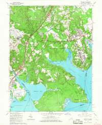 1965 Belvoir1967 Print · USGSFairfax County in the mid-sixties reveals a dense intersection of Cold War military operations and preserved colonial history along the Potomac shoreline. Researchers can trace ancestral sites at Pohick Ch and Gunston Hall, or locate family homes in Newington and Harbor View.4 unique versions available
 - 1966 Map of Occoquan, 1968 Print
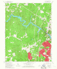 1966 Occoquan1968 Print · USGSPrince William County is shown in a period of transition during the mid-sixties, as planned communities like Dale City emerge alongside the Occoquan Reservoir. Trace family roots at Oak Grove Ch or locate the site of the former Woodbridge Airport.4 unique versions available
End of results
Showing maps 1-3 of 3
Top cities near Lorton
- Washington historical maps
- Arlington historical maps
- Alexandria historical maps
- Dale City historical maps
- Centreville historical maps
- Lake Ridge historical maps
See more
Top neighborhoods of Lorton
- Laurel Hill historical maps
- Laurel Crest historical maps
- Liberty historical maps
- Lorfax Heights historical maps
- Spring Hill historical maps
Frequently asked questions
- What are the different types of historical maps available for Lorton?
- What is the oldest map of Lorton?
- Where can I purchase historical maps of Lorton for my home or office?
- Where can I download high-res historical maps of Lorton?
- Are there historical topographic maps available for Lorton?
- Is there historical aerial imagery available for Lorton?
- Where are historical maps of Lorton sourced from?