1900s (20th Century) Maps of Aspen Woods, Goochland County
Explore 11 historic maps of Aspen Woods from the 1900s (20th Century). These maps offer a rare glimpse into what life looked like during the 1900s — showing old roads, neighborhoods, homes, and landmarks that have changed or disappeared over time.
Whether you're researching your family's past, planning a metal detecting trip, or studying how Aspen Woods's landscape evolved across the 1900s, these high-resolution maps are a powerful tool for exploring the history of this region.
- Focus on a specific era: All maps on this page are from the 1900s, giving you a focused view of this time period.
- See what’s changed: Compare century-old streets, trails, and buildings to today's modern landscape using overlays and satellite layers.
- Research with precision: Use these maps for genealogy, historical research, land use analysis, or educational projects.
- View, download, or print: Maps are fully viewable online in high resolution, and can be downloaded or printed for your own records.
Start exploring Aspen Woods's history through authentic maps from the 1900s. This is your window into the past.
Aspen Woods, Goochland County maps
(11)- 1943 Map of Goochland
 1943 Goochland1943 Print · USGSGoochland County and the James River valley are shown here during the early 1940s, highlighting the area's river-and-rail infrastructure. Genealogists can trace family landmarks like Leakes Mill, Ragland Memorial Church, and the rural community of Three Square.2 unique versions available
 - 1943 Map of Perkinsville
 1943 Perkinsville1943 Print · USGSGoochland County at the height of the Second World War remains a landscape of rural stores and riverside rail transport. Genealogists and historians can trace the foundations of State Farm, find old community hubs like Gammons Store, or locate country parishes such as Hebron Church.2 unique versions available
 - 1943 Map of Richmond, 1972 Print
 1943 Richmond1972 Print · USGSCoastal Virginia and the state capital are shown in detail during the mid-century era of infrastructure expansion. Genealogists and historians can trace the grounds of Richmond Nat Battlefield Park, locate the Yorktown Nat Cem, or follow the many rural routes through Amelia Court House and Tappahannock.
 - 1949 Map of Richmond, 1951 Print
 1949 Richmond1951 Print · USGSCoastal Virginia in the years following World War II remained a landscape of historic river towns and expanding military bases. Genealogists and historians can trace the rail lines of the Southern Ry and locate established landmarks from Camp Lee to the remote reaches of Dragon Swamp.
 - 1959 Map of Richmond
 1959 Richmond1959 Print · USGSMid-century Virginia is captured here at its most vital rail and river junctions, from the capital city to the Chesapeake Bay. Genealogists and historians can trace the development of colonial settlements like Williamsburg and military landmarks including Fort Monroe and Camp Lee.
 - 1964 Map of Richmond
 1964 Richmond1964 Print · USGSCoastal and central Virginia are mapped during the mid-twentieth century, showing the critical intersection of rail, river, and military life. Genealogists can trace family roots through rural county seats like Amelia or find vanished coastal neighborhoods near Phoebus and Hilton Village.
 - 1968 Map of Perkinsville, 1970 Print
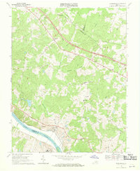 1968 Perkinsville1970 Print · USGSGoochland County in the late sixties reveals a landscape of Piedmont ridges and river-bottom industry along the James River. Genealogists and local historians can trace family locations near Gammons Store, Randolph Sch, and the State Farm Penal Institution.3 unique versions available
 - 1968 Map of Goochland, 1970 Print
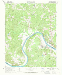 1968 Goochland1970 Print · USGSGoochland County and the James River are captured in the late sixties as the region maintained its rural and institutional character. Trace the river-and-rail corridor through Maidens and locate local landmarks like Byrd Ch and the State Farm for Women.4 unique versions available
 - 1973 Map of Richmond, 1974 Print
 1973 Richmond1974 Print · USGSThe Virginia Tidewater and Piedmont come alive in the early seventies, showcasing a region defined by its great rivers and massive military installations. Researchers can trace the mid-century growth of Richmond or locate family sites near Amelia Court House and Highland Springs.2 unique versions available
 - 1979 Map of Goochland, 1982 Print
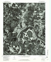 1979 Goochland1982 Print · USGSGoochland and the James River valley are captured in high-detail aerial photography during the late seventies. Researchers can trace rural land divisions and crossroads settlements such as Dogtown, Three Square, and the riverfront at Beaumont.
 - 1984 Map of Richmond, 1986 Print
 1984 Richmond1986 Print · USGSCentral Virginia during the mid-eighties shows a landscape of rapid suburban expansion centered on the state capital and its historic riverfront. Genealogists and historians can trace institutional sites like Randolph-Macon College, the grounds of Fort Lee, and small community landmarks like Hebron Ch.3 unique versions available
End of results
Showing maps 1-11 of 11
Frequently asked questions
- What are the different types of historical maps available for Aspen Woods?
- What is the oldest map of Aspen Woods?
- Where can I purchase historical maps of Aspen Woods for my home or office?
- Where can I download high-res historical maps of Aspen Woods?
- Are there historical topographic maps available for Aspen Woods?
- Is there historical aerial imagery available for Aspen Woods?
- Where are historical maps of Aspen Woods sourced from?