
1943 Map of Goochland
USGS Topo · Published 1943About this map
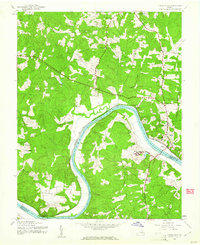
The James River carves a deep horseshoe bend through the heart of the Piedmont, serving as the physical and economic divide between Goochland County and Powhatan County. Along its northern bank, the Chesapeake and Ohio railroad corridor anchors small riverside communities like Maidens and Irwin, while the county seat at Goochland sits elevated above the floodplains. This 1943 survey captures the landscape of the Virginia interior during a period of institutional expansion, clearly marking the Virginia Industrial Farm for Women and the Virginia Industrial School for Boys on opposite sides of the river.
Find a feature on this map
33 named features on this map. Tap any name to fly to it.
Don’t see what you’re looking for? This feature index may not catch every label — zoom into the map to look around manually.
Map Details
Editions of this 1943 Goochland Map
2 editions found
Other maps of this area

1890 · Goochland
USGS Topo · 1:125,000

1891 · Palmyra
USGS Topo · 1:125,000

1892 · Goochland
USGS Topo · 1:125,000

1895 · Palmyra
USGS Topo · 1:125,000

1897 · Palmyra
USGS Topo · 1:125,000

1943 · Fine Creek Mills
USGS Topo · 1:31,680

1943 · Powhatan
USGS Topo · 1:31,680

1943 · Perkinsville
USGS Topo · 1:31,680
1943 · South Anna
USGS Topo · 1:24,000
1943 · Dabneys
USGS Topo · 1:24,000